IMAGES TAKEN NEAR TO
Beech Street, PONTEFRACT, WF9 2LT
Introduction
This page details the photographs taken nearby to Beech Street, WF9 2LT by members of the Geograph project.
The Geograph project started in 2005 with the aim of publishing, organising and preserving representative images for every square kilometre of Great Britain, Ireland and the Isle of Man.

There are currently over 7.5m images from over14,400 individuals and you can help contribute to the project by visiting https://www.geograph.org.uk
Image Map
Images are licensed for reuse under creativecommons.org/licenses/by-sa/2.0
Notes
- Clicking on the map will re-center to the selected point.
- The higher the marker number, the further away the image location is from the centre of the postcode.
Image Listing (28 Images Found)
Images are licensed for reuse under creativecommons.org/licenses/by-sa/2.0
Image
Details
Distance
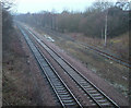
2
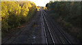
Railway line
Looking North from Broad Lane.
Image: © Steve Fareham
Taken: 28 Oct 2007
0.06 miles
7
Railway Lines
Looking North towards Moorthorpe from Bridge
Image: © Richard Spencer
Taken: 5 Feb 2006
0.12 miles