IMAGES TAKEN NEAR TO
Quarry Lane, PONTEFRACT, WF9 1DA
Introduction
This page details the photographs taken nearby to Quarry Lane, WF9 1DA by members of the Geograph project.
The Geograph project started in 2005 with the aim of publishing, organising and preserving representative images for every square kilometre of Great Britain, Ireland and the Isle of Man.

There are currently over 7.5m images from over14,400 individuals and you can help contribute to the project by visiting https://www.geograph.org.uk
Image Map
Images are licensed for reuse under creativecommons.org/licenses/by-sa/2.0
Notes
- Clicking on the map will re-center to the selected point.
- The higher the marker number, the further away the image location is from the centre of the postcode.
Image Listing (26 Images Found)
Images are licensed for reuse under creativecommons.org/licenses/by-sa/2.0
Image
Details
Distance
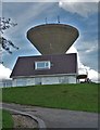
5
Beacon Hill, Upton, with a view of the Water Tower.
Image: © Bill Henderson
Taken: 11 Sep 2006
0.15 miles
6
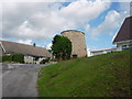
Upton tower mill, West Yorkshire
Stump of a tower mill near the water tower on Beacon Hill in the grounds of "Adastra" house.
Image: © Bob Paterson
Taken: 28 Aug 2006
0.15 miles
7
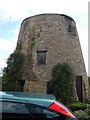
Upton tower mill, West Yorkshire
Another view - but with the house "Adastra" behind you.
Image: © Bob Paterson
Taken: 28 Aug 2006
0.15 miles
8
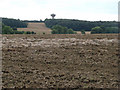
View over farmland at Thorpe Audlin to Upton Water Tower.
Image: © Bill Henderson
Taken: 17 Aug 2007
0.15 miles
9
The water tower at Upton Beacon
Soaring above a house as its owner cuts the surrounding grass aboard a ride-on lawnmower with his grandson on his lap.
Image: © Neil Theasby
Taken: 8 Aug 2019
0.16 miles
10
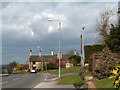
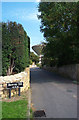
Road junction in Upton
Upton is a village of some size near to the A1. The B6474 passes through the western half of the place and here is seen at a junction with a residential road which also leads to a water tower.
Image: © Trevor Littlewood
Taken: 11 Mar 2011
0.16 miles