IMAGES TAKEN NEAR TO
St. Josephs Mount, PONTEFRACT, WF8 4JP
Introduction
This page details the photographs taken nearby to St. Josephs Mount, WF8 4JP by members of the Geograph project.
The Geograph project started in 2005 with the aim of publishing, organising and preserving representative images for every square kilometre of Great Britain, Ireland and the Isle of Man.

There are currently over 7.5m images from over14,400 individuals and you can help contribute to the project by visiting https://www.geograph.org.uk
Image Map
Images are licensed for reuse under creativecommons.org/licenses/by-sa/2.0
Notes
- Clicking on the map will re-center to the selected point.
- The higher the marker number, the further away the image location is from the centre of the postcode.
Image Listing (69 Images Found)
Images are licensed for reuse under creativecommons.org/licenses/by-sa/2.0
Image
Details
Distance
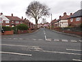
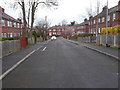
2
Westbourne Avenue - Westbourne Crescent
Image: © Betty Longbottom
Taken: 29 Mar 2017
0.05 miles
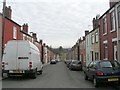
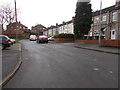
3
Mill Hill Stores, junction of Mill Hill Lane and Alden Crescent
Image: © Bill Henderson
Taken: 10 Oct 2007
0.05 miles
4
Westbourne Mount - Westbourne Crescent
Image: © Betty Longbottom
Taken: 29 Mar 2017
0.06 miles
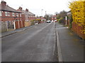
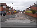
6
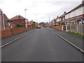
St Joseph's Mount - Mill Hill Lane
Image: © Betty Longbottom
Taken: 29 Mar 2017
0.07 miles
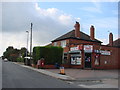
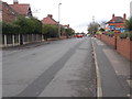
7
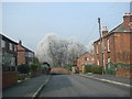
St Joseph's Mount , junction with Wakefield Road, on a frosty morning
Image: © Bill Henderson
Taken: 20 Feb 2008
0.07 miles
9
Mill Hill Lane - viewed from St Joseph's Mount
Image: © Betty Longbottom
Taken: 29 Mar 2017
0.09 miles