IMAGES TAKEN NEAR TO
Harewood Avenue, PONTEFRACT, WF8 2AG
Introduction
This page details the photographs taken nearby to Harewood Avenue, WF8 2AG by members of the Geograph project.
The Geograph project started in 2005 with the aim of publishing, organising and preserving representative images for every square kilometre of Great Britain, Ireland and the Isle of Man.

There are currently over 7.5m images from over14,400 individuals and you can help contribute to the project by visiting https://www.geograph.org.uk
Image Map
Images are licensed for reuse under creativecommons.org/licenses/by-sa/2.0
Notes
- Clicking on the map will re-center to the selected point.
- The higher the marker number, the further away the image location is from the centre of the postcode.
Image Listing (20 Images Found)
Images are licensed for reuse under creativecommons.org/licenses/by-sa/2.0
Image
Details
Distance

4
St Mary's Chequerfield, Pontefract
This Church has now been demolished and a community centre now stands on the site.
Image: © Bill Henderson
Taken: Unknown
0.12 miles
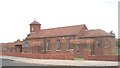
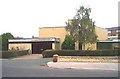
5
St. Mary's Community Centre, Chequerfield
Replaced the original St. Mary's church which was contemporary with the surrounding housing.
Image: © Jonathan Thacker
Taken: 18 Aug 2009
0.13 miles
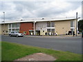
6
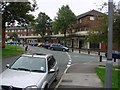
Chequerfield Circle Shops, Chequerfield Estate, Pontefract
Image: © Bill Henderson
Taken: 16 Sep 2006
0.13 miles
7

St. Mary's Community Centre, Chequerfield
View of the rear of the Community Centre.
Image: © Jonathan Thacker
Taken: 18 Aug 2009
0.14 miles
8
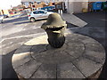
Urn from the top of the Waterloo Monument ('Cranky pin')
Pontefract used to have a monument to the battle of Waterloo. The monument was built in 1818, but demolished on January 2nd, 1946. Locally the Waterloo monument was known as 'Cranky pin' because it leaned over, a bit like the Chesterfield spire. The urn from the top of 'Cranky pin' was kept in the grounds of the Monument House rehabilitation facility. This rehab facility has now also been demolished. I'm unsure where the urn is now.
Image: © Phillip Beadham
Taken: 2 Mar 2015
0.15 miles
9
Chequerfield, Pontefract, R.C. Church of the Holy Family
Image: © Bill Henderson
Taken: Unknown
0.16 miles
