IMAGES TAKEN NEAR TO
Grove Road, PONTEFRACT, WF8 1ED
Introduction
This page details the photographs taken nearby to Grove Road, WF8 1ED by members of the Geograph project.
The Geograph project started in 2005 with the aim of publishing, organising and preserving representative images for every square kilometre of Great Britain, Ireland and the Isle of Man.

There are currently over 7.5m images from over14,400 individuals and you can help contribute to the project by visiting https://www.geograph.org.uk
Image Map
Images are licensed for reuse under creativecommons.org/licenses/by-sa/2.0
Notes
- Clicking on the map will re-center to the selected point.
- The higher the marker number, the further away the image location is from the centre of the postcode.
Image Listing (30 Images Found)
Images are licensed for reuse under creativecommons.org/licenses/by-sa/2.0
Image
Details
Distance

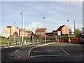
8
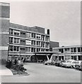
Pontefract General Infirmary
The Friarwood entrance to the hospital. I understand the hospital has been virtually completely rebuilt since this time.
Image: © Gerald England
Taken: Unknown
0.10 miles
9
Priory Chase, new housing development
Image: © Bill Henderson
Taken: 30 Nov 2012
0.12 miles