
IMAGES TAKEN NEAR TO
Doncaster Road, PONTEFRACT, WF7 7BX
Introduction
This page details the photographs taken nearby to Doncaster Road, WF7 7BX by members of the Geograph project.
The Geograph project started in 2005 with the aim of publishing, organising and preserving representative images for every square kilometre of Great Britain, Ireland and the Isle of Man.

There are currently over 7.5m images from over14,400 individuals and you can help contribute to the project by visiting https://www.geograph.org.uk
Image Map
Images are licensed for reuse under creativecommons.org/licenses/by-sa/2.0
Notes
- Clicking on the map will re-center to the selected point.
- The higher the marker number, the further away the image location is from the centre of the postcode.
Image Listing (114 Images Found)
Images are licensed for reuse under creativecommons.org/licenses/by-sa/2.0
Image
Details
Distance

2

Beverley Arms public house
On the roundabout at Ackworth.
Image: © Steve Fareham
Taken: 23 Feb 2008
0.01 miles
3

Forecourt of The Beverley Arms at Ackworth roundabout
Image: © Steve Fareham
Taken: 23 Feb 2016
0.01 miles
4
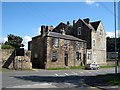
Large Stone House
This must be one of the largest Victorian stone built houses in the vicinity, and I am reliably informed that at one time it was the manse.
Image: © Mike Kirby
Taken: 27 Aug 2008
0.03 miles
5

Ackworth garden centre
This garden centre appears to stock all your gardening requirements from plants to pots, to paving.
Image: © Mike Kirby
Taken: 17 Aug 2008
0.04 miles
6

Milestone
Located between the garden centre and the Co-op.
Image: © Mike Kirby
Taken: 17 Aug 2008
0.04 miles
7

Old milepost
This milepost from the Barnsley to Pontefract tollroad is near the bus stop on the A628 in Ackworth just north of the roundabout with the A638. It is known that it was painted in 2005. Most of the mileposts on this route do not have a backing stone so this one, larger than the casting, is probably a 20C addition. This post is the only one of those remaining that is not 'Listed'.
Image: © Chris Minto
Taken: 10 Apr 2022
0.04 miles
8

Turnpike milepost
Erected for the Barnsley and Pontefract Turnpike trust. This turnpike was created under two Acts of Parliament. The first in 1825 created a new road from Barnsley to Cundy Cross and then created the new road through what became Lundwood to arrive at Cudworth Dike bridge. The Second Act in 1833 continued the road through Cudworth, Shafton Two Gates, Brierley, to Hemsworth. At Ackworth Moor Top (a new settlement) it crossed the Red House to Wakefield Turnpike, proceeding to High Ackworth and then on through to join an older turnpike from Doncaster to Pontefract, just a little south of the town.
Image: © John Orchard
Taken: 29 Jun 2012
0.04 miles
9

Old Milestone by the A628, Ackworth Moor Top
Metal plate attached to stone post by the A628, in parish of WAKEFIELD (WAKEFIELD District), Ackworth Moor Top, just North of roundabout junction with A638, on the verge next to bus stop, on West side of road. Barnsley/Pontefract, Grove Foundry iron casting, erected by the County Council in the 19th/20th century.
Inscription reads:-
: PON.T / 4 / MILES : : BARNSLEY & PONTEFRACT ROAD / ACKWORTH : : BARN.Y / 10 / MILES :
Milestone Society National ID: YW_BNPO10.
Image: © C Minto
Taken: 1 Aug 2001
0.05 miles
10

Supermarket
Ackworth Moor Top Co-op. The only supermarket in the area, so, always busy.
Image: © Mike Kirby
Taken: 17 Aug 2008
0.06 miles