
IMAGES TAKEN NEAR TO
West View, PONTEFRACT, WF7 7AJ
Introduction
This page details the photographs taken nearby to West View, WF7 7AJ by members of the Geograph project.
The Geograph project started in 2005 with the aim of publishing, organising and preserving representative images for every square kilometre of Great Britain, Ireland and the Isle of Man.

There are currently over 7.5m images from over14,400 individuals and you can help contribute to the project by visiting https://www.geograph.org.uk
Image Map
Images are licensed for reuse under creativecommons.org/licenses/by-sa/2.0
Notes
- Clicking on the map will re-center to the selected point.
- The higher the marker number, the further away the image location is from the centre of the postcode.
Image Listing (52 Images Found)
Images are licensed for reuse under creativecommons.org/licenses/by-sa/2.0
Image
Details
Distance
1

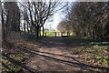
Walkway
This section of Dando Way runs from Wakefield Road to Rose Lane, alongside the aggregate plant.
Image: © Mike Kirby
Taken: 27 Aug 2008
0.03 miles

4

Subway under Wakefield Road
Leaving Fitzwilliam country park.
Image: © Steve Fareham
Taken: 18 Apr 2009
0.06 miles
5

Underpass
This underpass goes under Wakefield Road, taking the walkway, Dando Way, all the way to Fitzwilliam Country Park.
Image: © Mike Kirby
Taken: 27 Aug 2008
0.06 miles

7

A shady walkway to Kinsley country park
To the right of the photo is a Lafarge aggregate plant.
Image: © Steve Fareham
Taken: 18 Apr 2009
0.07 miles

9
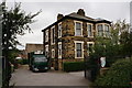
Taylor's Butchers on Wakefield Road, Brackenhill
Image: © Ian S
Taken: 30 Jul 2014
0.09 miles
10
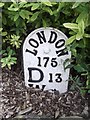
Old Milestone by the A638, Wakefield Road, Ackworth
Metal plate attached to stone post by the A638, in parish of ACKWORTH (WAKEFIELD District), Ackworth Moor Top, ¾ mile West of A628 junction, in little garden at front of house, at corner of Dicky Sykes Lane, on South side of road. DW iron plate, erected by the Red House & Crofton turnpike trust in the 18th century.
Inscription reads:-
LONDON
175
D 13
W 7
(To Doncaster and Wakefield)
Carved bench mark on side.
Milestone Society National ID: YW_DNWK13.
Image: © C Minto
Taken: 4 Jul 2002
0.10 miles