IMAGES TAKEN NEAR TO
Gleneagles Road, PONTEFRACT, WF7 6NA
Introduction
This page details the photographs taken nearby to Gleneagles Road, WF7 6NA by members of the Geograph project.
The Geograph project started in 2005 with the aim of publishing, organising and preserving representative images for every square kilometre of Great Britain, Ireland and the Isle of Man.

There are currently over 7.5m images from over14,400 individuals and you can help contribute to the project by visiting https://www.geograph.org.uk
Image Map
Images are licensed for reuse under creativecommons.org/licenses/by-sa/2.0
Notes
- Clicking on the map will re-center to the selected point.
- The higher the marker number, the further away the image location is from the centre of the postcode.
Image Listing (20 Images Found)
Images are licensed for reuse under creativecommons.org/licenses/by-sa/2.0
Image
Details
Distance
1
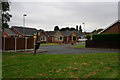
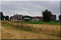
Bungalows on Muirfield Avenue, North Featherstone
Image: © Ian S
Taken: 30 Jul 2014
0.07 miles
2
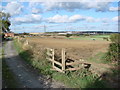
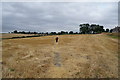
Useless Stile
The gap at the side of this stile on the footpath between Pontefract Park and North Featherstone, renders it absolutely useless.
Image: © Bill Henderson
Taken: 17 Oct 2007
0.07 miles
3
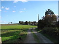
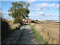
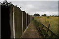
Track from Park Farm towards Park Lane
Image: © Bill Henderson
Taken: 17 Oct 2007
0.08 miles
5
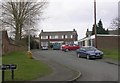
Path to the rear of Muirfield Avenue, North Featherstone
Image: © Ian S
Taken: 30 Jul 2014
0.09 miles
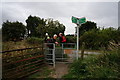
6
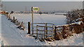
New style gate and fence
This replaces the old stile listed as Useless stile
Image: © Jailer
Taken: 22 Jan 2013
0.09 miles