IMAGES TAKEN NEAR TO
Wellgarth Road, PONTEFRACT, WF7 5LZ
Introduction
This page details the photographs taken nearby to Wellgarth Road, WF7 5LZ by members of the Geograph project.
The Geograph project started in 2005 with the aim of publishing, organising and preserving representative images for every square kilometre of Great Britain, Ireland and the Isle of Man.

There are currently over 7.5m images from over14,400 individuals and you can help contribute to the project by visiting https://www.geograph.org.uk
Image Map
Images are licensed for reuse under creativecommons.org/licenses/by-sa/2.0
Notes
- Clicking on the map will re-center to the selected point.
- The higher the marker number, the further away the image location is from the centre of the postcode.
Image Listing (30 Images Found)
Images are licensed for reuse under creativecommons.org/licenses/by-sa/2.0
Image
Details
Distance
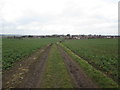
1
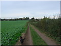
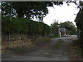
Public Footpath entering Purston
This is where the footpath from Castle Syke Hill, Ackworth enters Purston.
Image: © Bill Henderson
Taken: 16 Oct 2007
0.08 miles
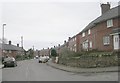
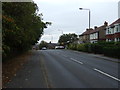
3
Hall Street - viewed from Wentbridge Road
Image: © Betty Longbottom
Taken: 7 Mar 2009
0.09 miles
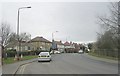
7
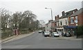
Hall Street - viewed from Wentbridge Road
Image: © Betty Longbottom
Taken: 7 Mar 2009
0.13 miles
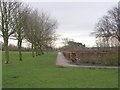
9
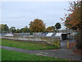
Skate Board and BMX area, Purston Park
Image: © Bill Henderson
Taken: 14 Oct 2007
0.16 miles