IMAGES TAKEN NEAR TO
Wakefield Road, PONTEFRACT, WF7 5BP
Introduction
This page details the photographs taken nearby to Wakefield Road, WF7 5BP by members of the Geograph project.
The Geograph project started in 2005 with the aim of publishing, organising and preserving representative images for every square kilometre of Great Britain, Ireland and the Isle of Man.

There are currently over 7.5m images from over14,400 individuals and you can help contribute to the project by visiting https://www.geograph.org.uk
Image Map
Images are licensed for reuse under creativecommons.org/licenses/by-sa/2.0
Notes
- Clicking on the map will re-center to the selected point.
- The higher the marker number, the further away the image location is from the centre of the postcode.
Image Listing (24 Images Found)
Images are licensed for reuse under creativecommons.org/licenses/by-sa/2.0
Image
Details
Distance
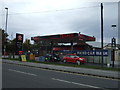
1
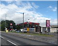
Fuel Service Station - Wakefield Road
Image: © Anthony Parkes
Taken: 22 Jun 2013
0.01 miles
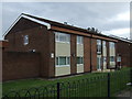
4
Houses and bungalows on Priordale Road
Just off Wentworth Road.
Image: © Christine Johnstone
Taken: 10 Nov 2010
0.10 miles
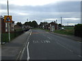
5
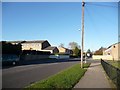
Wentworth Road, Featherstone
Looking towards Wakefield Road.
Image: © Christine Johnstone
Taken: 10 Nov 2010
0.11 miles
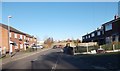
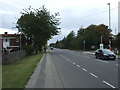
7
77 - 99 Wentworth Road, Featherstone
The houses on this side are built in blocks at right angles to the road.
Image: © Christine Johnstone
Taken: 10 Nov 2010
0.13 miles
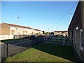
8
Access road off Wentworth Road
Between two parallel blocks of houses, which are at right angles to the 'main' road.
Image: © Christine Johnstone
Taken: 10 Nov 2010
0.14 miles