IMAGES TAKEN NEAR TO
St. Michaels Green, NORMANTON, WF6 1PX
Introduction
This page details the photographs taken nearby to St. Michaels Green, WF6 1PX by members of the Geograph project.
The Geograph project started in 2005 with the aim of publishing, organising and preserving representative images for every square kilometre of Great Britain, Ireland and the Isle of Man.

There are currently over 7.5m images from over14,400 individuals and you can help contribute to the project by visiting https://www.geograph.org.uk
Image Map (74 Images)


Getting Data...Please wait
Leaflet Map data © OpenStreetMap
Images are licensed for reuse under creativecommons.org/licenses/by-sa/2.0
Notes
- Clicking on the map will re-center to the selected point.
- The higher the marker number, the further away the image location is from the centre of the postcode.
Image Listing (74 Images Found)
Images are licensed for reuse under creativecommons.org/licenses/by-sa/2.0
Image
Details
Distance
1

Newland Surgery
Newland Surgery off Newland Lane, Normanton.
Image: © Ian Russell
Taken: 15 Mar 2007
0.02 miles
2

St John the Baptist Catholic Church - Wakefield Road
Image: © Betty Longbottom
Taken: 18 Jul 2009
0.04 miles


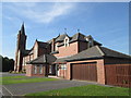
5

St John's Roman Catholic Church, Normanton
Image: © Neil Theasby
Taken: 18 Mar 2022
0.06 miles
6

St John the Baptist Catholic Church - Wakefield Road
Image: © Betty Longbottom
Taken: 18 Jul 2009
0.06 miles
8
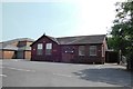
St John The Baptist Catholic Social Club, Normanton
Image: © Bill Henderson
Taken: 18 Jun 2013
0.07 miles
9

Track from Wakefield Road to Altofts
Image: © Betty Longbottom
Taken: 13 Jul 2010
0.08 miles
10
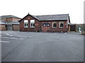
Catholic Social Club
St.John the Baptist Catholic Social Club on Newland Lane, Normanton.
Image: © Ian Russell
Taken: 15 Mar 2007
0.08 miles