IMAGES TAKEN NEAR TO
West Street, NORMANTON, WF6 1NL
Introduction
This page details the photographs taken nearby to West Street, WF6 1NL by members of the Geograph project.
The Geograph project started in 2005 with the aim of publishing, organising and preserving representative images for every square kilometre of Great Britain, Ireland and the Isle of Man.

There are currently over 7.5m images from over14,400 individuals and you can help contribute to the project by visiting https://www.geograph.org.uk
Image Map
Images are licensed for reuse under creativecommons.org/licenses/by-sa/2.0
Notes
- Clicking on the map will re-center to the selected point.
- The higher the marker number, the further away the image location is from the centre of the postcode.
Image Listing (221 Images Found)
Images are licensed for reuse under creativecommons.org/licenses/by-sa/2.0
Image
Details
Distance
4
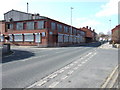
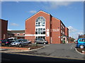
Clothing Factory
Harrison's clothing factory on Queen Street, Normanton. Now closed.
Image: © Ian Russell
Taken: 23 Mar 2007
0.03 miles
5
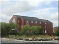
Queen Street Surgery
The new Queen Street Surgery in Normanton.
Image: © Ian Russell
Taken: 23 Mar 2007
0.03 miles
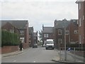
6
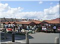
Market - viewed from Cross Queen Street
Image: © Betty Longbottom
Taken: 25 Jul 2009
0.03 miles
7
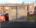
Electricity Substation No 3689 - Car Park - off Queen Street
Image: © Betty Longbottom
Taken: 23 Dec 2015
0.04 miles
8
Former School - Queen Street
Built as a school - then occupied as Council offices, the building is now derelict.
Image: © Betty Longbottom
Taken: 18 Jul 2009
0.05 miles
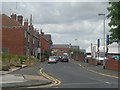
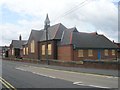
10
Normanton Conservative Club
on West Street.
Image: © Ian Russell
Taken: 23 Mar 2007
0.06 miles