IMAGES TAKEN NEAR TO
West View, OSSETT, WF5 8JG
Introduction
This page details the photographs taken nearby to West View, WF5 8JG by members of the Geograph project.
The Geograph project started in 2005 with the aim of publishing, organising and preserving representative images for every square kilometre of Great Britain, Ireland and the Isle of Man.

There are currently over 7.5m images from over14,400 individuals and you can help contribute to the project by visiting https://www.geograph.org.uk
Image Map
Images are licensed for reuse under creativecommons.org/licenses/by-sa/2.0
Notes
- Clicking on the map will re-center to the selected point.
- The higher the marker number, the further away the image location is from the centre of the postcode.
Image Listing (101 Images Found)
Images are licensed for reuse under creativecommons.org/licenses/by-sa/2.0
Image
Details
Distance
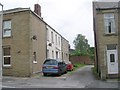
4
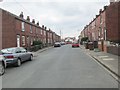
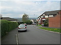
Westfield Street - looking towards Headlands Road
Image: © Betty Longbottom
Taken: 23 Apr 2014
0.03 miles
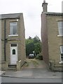
5
Marlborough Street - Headlands Road
Image: © Betty Longbottom
Taken: 23 Apr 2014
0.05 miles
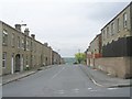
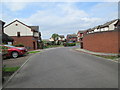
7
West Wells Crescent - West Wells Road
Image: © Betty Longbottom
Taken: 7 Jun 2010
0.06 miles
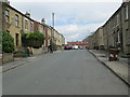
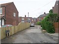
9
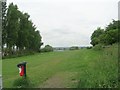
Recreation Ground - Westfield Street
Image: © Betty Longbottom
Taken: 7 Jun 2010
0.08 miles
10
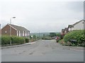
Headlands Park - viewed from Headlands Walk
Image: © Betty Longbottom
Taken: 23 Apr 2014
0.08 miles