IMAGES TAKEN NEAR TO
New Hall Lane, WAKEFIELD, WF4 4RP
Introduction
This page details the photographs taken nearby to New Hall Lane, WF4 4RP by members of the Geograph project.
The Geograph project started in 2005 with the aim of publishing, organising and preserving representative images for every square kilometre of Great Britain, Ireland and the Isle of Man.

There are currently over 7.5m images from over14,400 individuals and you can help contribute to the project by visiting https://www.geograph.org.uk
Image Map
Images are licensed for reuse under creativecommons.org/licenses/by-sa/2.0
Notes
- Clicking on the map will re-center to the selected point.
- The higher the marker number, the further away the image location is from the centre of the postcode.
Image Listing (10 Images Found)
Images are licensed for reuse under creativecommons.org/licenses/by-sa/2.0
Image
Details
Distance
4
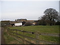
Farm machinery
A range of farm machinery at new Hall Farm.
Image: © John Illingworth
Taken: 5 Jun 2013
0.11 miles
6
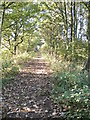
Straight on
This footpath was once a ropr haulled railway moving coal from a local colliery.
Image: © SMJ
Taken: Unknown
0.13 miles
7
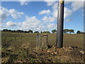
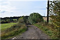
Stone post with benchmark north of New Hall Farm
To the right is one of the new poles for the overhead power lines.
Image: © John Slater
Taken: 24 Oct 2013
0.15 miles
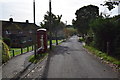
8
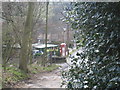
Phone Box in New Hall, Flockton
Red phone box in new hall, close to the prison. Taken from a track that leads to Middlestown.
Image: © jobomobo
Taken: 29 Mar 2008
0.15 miles
9
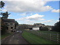
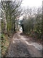
The track to New hall farm.
The Wakefield way.
Image: © steven ruffles
Taken: 7 Oct 2018
0.16 miles
10
New hall way.
The road that runs alongside the Prison/Young offenders centre.
Image: © steven ruffles
Taken: 7 Oct 2018
0.16 miles