IMAGES TAKEN NEAR TO
Ashwood Parade, WAKEFIELD, WF4 3GZ
Introduction
This page details the photographs taken nearby to Ashwood Parade, WF4 3GZ by members of the Geograph project.
The Geograph project started in 2005 with the aim of publishing, organising and preserving representative images for every square kilometre of Great Britain, Ireland and the Isle of Man.

There are currently over 7.5m images from over14,400 individuals and you can help contribute to the project by visiting https://www.geograph.org.uk
Image Map
Images are licensed for reuse under creativecommons.org/licenses/by-sa/2.0
Notes
- Clicking on the map will re-center to the selected point.
- The higher the marker number, the further away the image location is from the centre of the postcode.
Image Listing (54 Images Found)
Images are licensed for reuse under creativecommons.org/licenses/by-sa/2.0
Image
Details
Distance
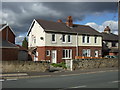
1
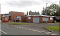
Pizza or Kebab
Fast food at Hall Green next to the community centre.
Image: © Steve Fareham
Taken: 30 Sep 2007
0.03 miles
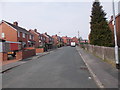
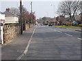
2
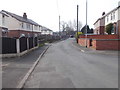
Micklethwaite Road - viewed from Cross Road
Image: © Betty Longbottom
Taken: 11 Apr 2016
0.04 miles
4
Micklethwaite Road - viewed from Cross Road
Image: © Betty Longbottom
Taken: 11 Apr 2016
0.04 miles
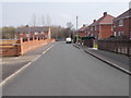
6
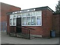
Hall Green Community Centre -Painthorpe Lane
Image: © Betty Longbottom
Taken: 15 Apr 2008
0.05 miles

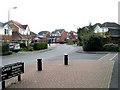
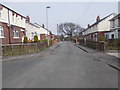
10
Stoney Lane - viewed from Painthorpe Lane
Image: © Betty Longbottom
Taken: 11 Apr 2016
0.07 miles