IMAGES TAKEN NEAR TO
Woolley Low Moor Lane, WAKEFIELD, WF4 2LN
Introduction
This page details the photographs taken nearby to Woolley Low Moor Lane, WF4 2LN by members of the Geograph project.
The Geograph project started in 2005 with the aim of publishing, organising and preserving representative images for every square kilometre of Great Britain, Ireland and the Isle of Man.

There are currently over 7.5m images from over14,400 individuals and you can help contribute to the project by visiting https://www.geograph.org.uk
Image Map
Images are licensed for reuse under creativecommons.org/licenses/by-sa/2.0
Notes
- Clicking on the map will re-center to the selected point.
- The higher the marker number, the further away the image location is from the centre of the postcode.
Image Listing (9 Images Found)
Images are licensed for reuse under creativecommons.org/licenses/by-sa/2.0
Image
Details
Distance
1
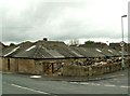
Woolley Moor Farm
On the junction of Woolley Low Moor Lane and Low Moor Lane
Image: © John Fielding
Taken: 16 May 2007
0.01 miles
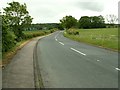
2
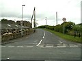
Low Moor Lane
At the junction with Woolley Low Moor Lane.
Image: © John Fielding
Taken: 16 May 2007
0.02 miles
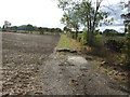
5
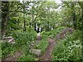
Woodland, Woolley Low Moor Lane
Unsure if masonry is due to tipping or a local ruin.
Image: © Richard Webb
Taken: 30 May 2023
0.10 miles
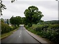
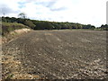
7
Woolley Low Moor Lane
From the junction at Daw Lane.
Image: © John Fielding
Taken: 16 May 2007
0.20 miles
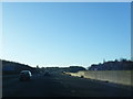
8
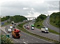
M1 South from Dennington Lane Bridge
The left hand slip road is to Woolley Services going south. The right hand slip road is from Woolley Services going north. Junction 38 Haigh is the next exit from the M1 going south.
Image: © John Fielding
Taken: 16 May 2007
0.24 miles
9
M1 southbound nears Woolley Edge Services
Image: © Colin Pyle
Taken: 13 Dec 2014
0.24 miles