IMAGES TAKEN NEAR TO
Hillcrest, WAKEFIELD, WF4 2EW
Introduction
This page details the photographs taken nearby to Hillcrest, WF4 2EW by members of the Geograph project.
The Geograph project started in 2005 with the aim of publishing, organising and preserving representative images for every square kilometre of Great Britain, Ireland and the Isle of Man.

There are currently over 7.5m images from over14,400 individuals and you can help contribute to the project by visiting https://www.geograph.org.uk
Image Map (22 Images)


Leaflet Map data © OpenStreetMap
Images are licensed for reuse under creativecommons.org/licenses/by-sa/2.0
Notes
- Clicking on the map will re-center to the selected point.
- The higher the marker number, the further away the image location is from the centre of the postcode.
Image Listing (22 Images Found)
Images are licensed for reuse under creativecommons.org/licenses/by-sa/2.0
Image
Details
Distance
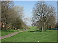
1
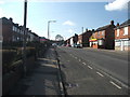
Havercroft.
Looking SW on Newstead Lane.
Image: © Steve Partridge
Taken: 20 Feb 2006
0.05 miles
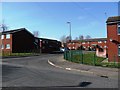
3

Footpath to Church View Close, Havercroft
Image: © Christine Johnstone
Taken: 11 Mar 2010
0.11 miles
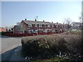
4
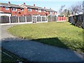
Open space behind houses in Madeley Road, Havercroft
Image: © Christine Johnstone
Taken: 11 Mar 2010
0.11 miles
5

Cow Lane crosses the site of a disused railway line
Image: © Colin Pyle
Taken: 4 Jul 2012
0.11 miles

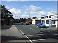
10
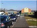
GP's practice and pharmacy, Madeley Road, Havercroft
Image: © Christine Johnstone
Taken: 11 Mar 2010
0.14 miles