IMAGES TAKEN NEAR TO
Ash Crescent, WAKEFIELD, WF3 4NX
Introduction
This page details the photographs taken nearby to Ash Crescent, WF3 4NX by members of the Geograph project.
The Geograph project started in 2005 with the aim of publishing, organising and preserving representative images for every square kilometre of Great Britain, Ireland and the Isle of Man.

There are currently over 7.5m images from over14,400 individuals and you can help contribute to the project by visiting https://www.geograph.org.uk
Image Map
Images are licensed for reuse under creativecommons.org/licenses/by-sa/2.0
Notes
- Clicking on the map will re-center to the selected point.
- The higher the marker number, the further away the image location is from the centre of the postcode.
Image Listing (183 Images Found)
Images are licensed for reuse under creativecommons.org/licenses/by-sa/2.0
Image
Details
Distance

6
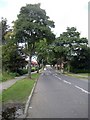
Tree lined road
A tree lined Limepit Lane takes you into the heart of Stanley village.
Image: © Mike Kirby
Taken: 24 Sep 2008
0.06 miles
7
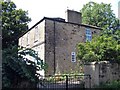
Vicarage
Located in Intake Lane,this is the vicarage for Stanley St Peter's church.
Image: © Mike Kirby
Taken: 15 Aug 2008
0.07 miles
9
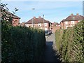
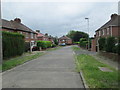
Footpath to Ash Crescent, Stanley
On the west side of Aberford Road.
Image: © Christine Johnstone
Taken: 10 Mar 2014
0.08 miles
10
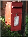
GR postbox
This George VI postbox looks neglected, but is still in use.
Image: © Mike Kirby
Taken: 24 Sep 2008
0.08 miles