IMAGES TAKEN NEAR TO
Aberford Road, WAKEFIELD, WF3 4NT
Introduction
This page details the photographs taken nearby to Aberford Road, WF3 4NT by members of the Geograph project.
The Geograph project started in 2005 with the aim of publishing, organising and preserving representative images for every square kilometre of Great Britain, Ireland and the Isle of Man.

There are currently over 7.5m images from over14,400 individuals and you can help contribute to the project by visiting https://www.geograph.org.uk
Image Map
Images are licensed for reuse under creativecommons.org/licenses/by-sa/2.0
Notes
- Clicking on the map will re-center to the selected point.
- The higher the marker number, the further away the image location is from the centre of the postcode.
Image Listing (189 Images Found)
Images are licensed for reuse under creativecommons.org/licenses/by-sa/2.0
Image
Details
Distance
1
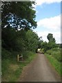
Nagger Lines
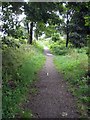
This section of the Trans Pennine Trail,(Nagger Lines) follows the old tram road from Aberford Road to Stanley Ferry. A solitary section of railway line is still visible. Image
Image: © Mike Kirby
Taken: 10 Sep 2008
0.01 miles
2
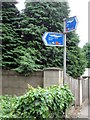
Sign post
Trans Pennine Trail, Route 67.
Image: © Mike Kirby
Taken: 10 Sep 2008
0.02 miles


5
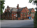
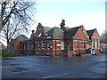
Stanley - Stanley Grove Primary School
For an alternative view, please see Betty Longbottom's Image
Image: © Dave Bevis
Taken: 31 May 2011
0.04 miles
7
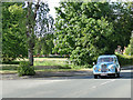
Vintage car on Aberford Road
This is, according to an enthusiast website, a 1953 Sunbeam Talbot 90. The reason it appears to be on the 'wrong' side of the road is that it was just coming out of a set of traffic-light-controlled roadworks.
Image: © Stephen Craven
Taken: 25 May 2020
0.05 miles
8
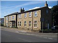
Stanley Victoria buildings
This building was originally the offices of the Victoria Mining Company, who operated the Deep Drop pit. When the pit closed it became the Stanley Victoria WMC and remained as so for many years. It then became the Grove Park nightspot.
It has now been converted into apartments.Image
Image: © Mike Kirby
Taken: 15 Aug 2008
0.05 miles
9
Trans Pennine Trail 67 (3)
A seat has recently been installed alongside TPT67, known locally as the Naggers, between the farm and Aberford Road.
Image: © Mike Kirby
Taken: 4 Jun 2011
0.06 miles
10
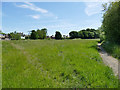
Stanley Marsh nature reserve: meadow
The eastern side of the reserve alongside Aberford Road is left to grass as a meadow area.
Image: © Stephen Craven
Taken: 25 May 2020
0.06 miles