IMAGES TAKEN NEAR TO
Aspen Mews, WF3 4GN
Introduction
This page details the photographs taken nearby to Aspen Mews, WF3 4GN by members of the Geograph project.
The Geograph project started in 2005 with the aim of publishing, organising and preserving representative images for every square kilometre of Great Britain, Ireland and the Isle of Man.

There are currently over 7.5m images from over14,400 individuals and you can help contribute to the project by visiting https://www.geograph.org.uk
Image Map
Images are licensed for reuse under creativecommons.org/licenses/by-sa/2.0
Notes
- Clicking on the map will re-center to the selected point.
- The higher the marker number, the further away the image location is from the centre of the postcode.
Image Listing (101 Images Found)
Images are licensed for reuse under creativecommons.org/licenses/by-sa/2.0
Image
Details
Distance
1
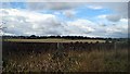
Open farmland
Looking over open farmland, Stanley Hall, centre picture, on the horizon. See Image
Image: © Mike Kirby
Taken: 23 Aug 2010
0.04 miles
2
New houses off Tree Top Drive
Part of the massive City Fields development. For a similar view when the site was empty, see Image which includes the same manhole cover.
Image: © Christine Johnstone
Taken: 1 Sep 2022
0.04 miles
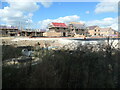
3
Construction site, off Nellie Spindler Drive
Part of the City Fields development, on the eastern side of Wakefield.
Image: © Christine Johnstone
Taken: 1 Sep 2022
0.05 miles
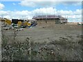
4
![City Fields, Wakefield East [11]](https://s3.geograph.org.uk/geophotos/04/85/15/4851511_5120c26b_120x120.jpg)
City Fields, Wakefield East [11]
A large housing development called 'City Fields' is being built on all the farmland between Stanley Ferry and the current edge of Wakefield.
Image: © Christine Johnstone
Taken: 14 Feb 2016
0.05 miles
5
New houses, off Tree Top Close, Wakefield
Part of the extensive City Fields development. For a view taken three years earlier, see Image
Image: © Christine Johnstone
Taken: 8 Apr 2023
0.06 miles
6
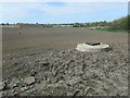
Manhole cover in a field off Nellie Spindler Drive
The greening field will give way to houses in a year or two, as part of the City Fields development.
Image: © Christine Johnstone
Taken: 13 Apr 2020
0.07 miles
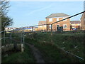
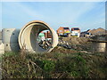
7
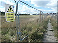
Public footpath from Stanley Flash to Neil Fox Way
Fenced off from a building site and a 'bucket changing area'.
Image: © Christine Johnstone
Taken: 1 Sep 2022
0.07 miles
8
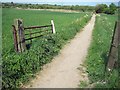
Countryside footpath (5)
Roughly threequarters down the path is this now disused farm gate.
Image: © Mike Kirby
Taken: 25 Apr 2011
0.07 miles
9
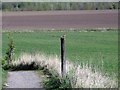
Countryside footpath (3)
Walking down the footpath we were greeted by a skylark in song, and the next thing he had settled on a fencepost about 20yds in front of us.
Image: © Mike Kirby
Taken: 9 Apr 2011
0.07 miles
10
City Fields construction site. Wakefield
Between Nellie Spindler Drive and Neil Fox Way.
Image: © Christine Johnstone
Taken: 8 Apr 2023
0.08 miles