IMAGES TAKEN NEAR TO
Moor Road, WAKEFIELD, WF3 4EW
Introduction
This page details the photographs taken nearby to Moor Road, WF3 4EW by members of the Geograph project.
The Geograph project started in 2005 with the aim of publishing, organising and preserving representative images for every square kilometre of Great Britain, Ireland and the Isle of Man.

There are currently over 7.5m images from over14,400 individuals and you can help contribute to the project by visiting https://www.geograph.org.uk
Image Map
Images are licensed for reuse under creativecommons.org/licenses/by-sa/2.0
Notes
- Clicking on the map will re-center to the selected point.
- The higher the marker number, the further away the image location is from the centre of the postcode.
Image Listing (40 Images Found)
Images are licensed for reuse under creativecommons.org/licenses/by-sa/2.0
Image
Details
Distance
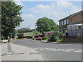
1
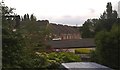
Houses in Moor Road
Seen from the Stanley Arms pub.
Image: © James Allan
Taken: 25 Jun 2016
0.02 miles
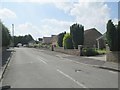
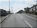
3
Moor Grove - looking towards Moor Road
Image: © Betty Longbottom
Taken: 23 Jun 2014
0.05 miles
5
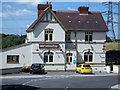
Bar Stanley
This pub was originally called the Ship Inn, then became the Stanley Arms (who sponsored the Stanley Rangers RLFC and provided changing facilities for the team). Once again it has changed hands and is now called Bar Stanley.
Image: © Mike Kirby
Taken: 21 Jul 2008
0.06 miles
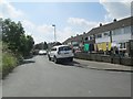
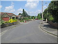
7
Lee Moor Road - viewed from Moor Road
Image: © Betty Longbottom
Taken: 23 Jun 2014
0.08 miles
9
Lee Moor Road - viewed from Moor Road
Image: © Betty Longbottom
Taken: 23 Jun 2014
0.08 miles
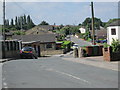
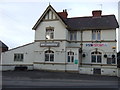
10
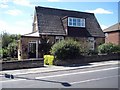
Old school house
This private house was once the Lee Moor school.
Image: © Mike Kirby
Taken: 21 Jul 2008
0.09 miles