IMAGES TAKEN NEAR TO
Virginia Court, WAKEFIELD, WF3 3TD
Introduction
This page details the photographs taken nearby to Virginia Court, WF3 3TD by members of the Geograph project.
The Geograph project started in 2005 with the aim of publishing, organising and preserving representative images for every square kilometre of Great Britain, Ireland and the Isle of Man.

There are currently over 7.5m images from over14,400 individuals and you can help contribute to the project by visiting https://www.geograph.org.uk
Image Map
Images are licensed for reuse under creativecommons.org/licenses/by-sa/2.0
Notes
- Clicking on the map will re-center to the selected point.
- The higher the marker number, the further away the image location is from the centre of the postcode.
Image Listing (74 Images Found)
Images are licensed for reuse under creativecommons.org/licenses/by-sa/2.0
Image
Details
Distance


3

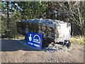
Lofthouse Colliery Park
The pathway follows the course of the railway line on the western perimeter of the park. Across the line is this electricity sub station.
Image: © Mike Kirby
Taken: 24 Jun 2009
0.08 miles
4

Lofthouse Colliery Nature Park - lupins (4)
Just over the fence from the park, lupins growing by the railway tracks.
Image: © Mike Kirby
Taken: 21 May 2011
0.08 miles
5

Lofthouse Colliery Nature Park, Heritage Trail #3
This information board gives graphic details of the colliery disaster which occurred in 1973.
Also, details of the obelisk and the mine car. Located on Silkstone path.
Image: © Mike Kirby
Taken: 4 Dec 2013
0.09 miles
6

Lofthouse Colliery Nature Park, Heritage Trail #8
Silkstone path, named after one of the coal seams at the former Lofthouse colliery.
Image: © Mike Kirby
Taken: 4 Dec 2013
0.09 miles
7

Lofthouse Colliery Nature Park - lupins (3)
This year, there is an abundance of lupins, of various colours, all over the park.
Image: © Mike Kirby
Taken: 21 May 2011
0.09 miles
8
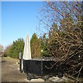
Lofthouse Colliery Nature Park, Heritage Trail #4
The memorial site,comprising the information board, obelisk, and mine car.
See Image This memorial was erected as near as possible to the exact spot underground where the victims of the disaster were entombed.
Image: © Mike Kirby
Taken: 4 Dec 2013
0.09 miles
9
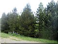
Lofthouse Colliery Nature Park - pine trees
A variety of pine trees can be found around the park.
Image: © Mike Kirby
Taken: 21 May 2011
0.10 miles
10
Lofthouse Colliery Nature Park, Heritage Trail #6
This model of mine car was used at the colliery from 1946, and carried 5 tons of coal.
Image: © Mike Kirby
Taken: 4 Dec 2013
0.10 miles