IMAGES TAKEN NEAR TO
New Road, WAKEFIELD, WF3 3RE
Introduction
This page details the photographs taken nearby to New Road, WF3 3RE by members of the Geograph project.
The Geograph project started in 2005 with the aim of publishing, organising and preserving representative images for every square kilometre of Great Britain, Ireland and the Isle of Man.

There are currently over 7.5m images from over14,400 individuals and you can help contribute to the project by visiting https://www.geograph.org.uk
Image Map
Images are licensed for reuse under creativecommons.org/licenses/by-sa/2.0
Notes
- Clicking on the map will re-center to the selected point.
- The higher the marker number, the further away the image location is from the centre of the postcode.
Image Listing (84 Images Found)
Images are licensed for reuse under creativecommons.org/licenses/by-sa/2.0
Image
Details
Distance
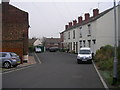
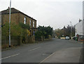
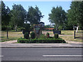
1
Main Street - viewed from Chapel Street
Image: © Betty Longbottom
Taken: 30 Oct 2009
0.01 miles
5
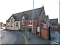
Carlton Primary School, from the north-east
Built in 1875 on New Road. This [northern] entrance is for meetings and staff only.
Image: © Christine Johnstone
Taken: 30 Dec 2014
0.04 miles
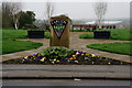
9
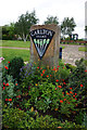
Millennium stone, Carlton village green
The greenery in front of the stone has grown since 2008 Image
Image: © Stephen Craven
Taken: 28 May 2020
0.04 miles