IMAGES TAKEN NEAR TO
Springfield Court, WAKEFIELD, WF3 3GB
Introduction
This page details the photographs taken nearby to Springfield Court, WF3 3GB by members of the Geograph project.
The Geograph project started in 2005 with the aim of publishing, organising and preserving representative images for every square kilometre of Great Britain, Ireland and the Isle of Man.

There are currently over 7.5m images from over14,400 individuals and you can help contribute to the project by visiting https://www.geograph.org.uk
Image Map
Images are licensed for reuse under creativecommons.org/licenses/by-sa/2.0
Notes
- Clicking on the map will re-center to the selected point.
- The higher the marker number, the further away the image location is from the centre of the postcode.
Image Listing (26 Images Found)
Images are licensed for reuse under creativecommons.org/licenses/by-sa/2.0
Image
Details
Distance
3
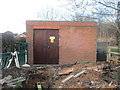
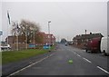
Electricity Substation No 835 - Leeds Road
Image: © Betty Longbottom
Taken: 7 Jan 2014
0.05 miles
4
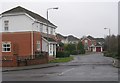
Lofthouse House Park Development - Leeds Road
Image: © Betty Longbottom
Taken: 18 Feb 2009
0.05 miles
5
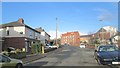
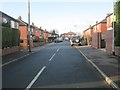
Park Avenue - Looking towards Park Drive
Image: © Betty Longbottom
Taken: 7 Jan 2014
0.07 miles
6
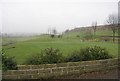
Lofthouse Hill Golf Course - Leeds Road
Image: © Betty Longbottom
Taken: 18 Feb 2009
0.12 miles
7
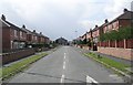
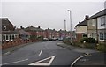
Johns Avenue - Leeds Road, Lofthouse Gate
Image: © Betty Longbottom
Taken: 8 Apr 2008
0.12 miles
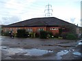
9
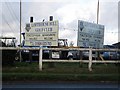
Lofthouse Hill Golf Club
Nigh impossible to get a shot of the clubhouse and sign together. SeeImage
Image: © Mike Kirby
Taken: 26 Oct 2008
0.14 miles