IMAGES TAKEN NEAR TO
Cliffe Terrace, WAKEFIELD, WF3 3BB
Introduction
This page details the photographs taken nearby to Cliffe Terrace, WF3 3BB by members of the Geograph project.
The Geograph project started in 2005 with the aim of publishing, organising and preserving representative images for every square kilometre of Great Britain, Ireland and the Isle of Man.

There are currently over 7.5m images from over14,400 individuals and you can help contribute to the project by visiting https://www.geograph.org.uk
Image Map
Images are licensed for reuse under creativecommons.org/licenses/by-sa/2.0
Notes
- Clicking on the map will re-center to the selected point.
- The higher the marker number, the further away the image location is from the centre of the postcode.
Image Listing (73 Images Found)
Images are licensed for reuse under creativecommons.org/licenses/by-sa/2.0
Image
Details
Distance

3
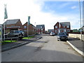
Apartment block Robin Hood
Alongside the main Wakefield Leeds Road.
Image: © Steve Fareham
Taken: 30 Jan 2004
0.06 miles
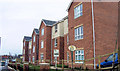
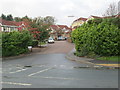
6
The Rowans Development - Leeds Road
Image: © Betty Longbottom
Taken: 30 Oct 2013
0.09 miles
8
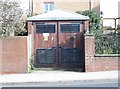
Electricity Substation No 43910 - Leeds Road
Image: © Betty Longbottom
Taken: 30 Oct 2013
0.09 miles
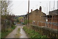
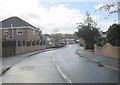
10
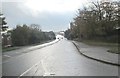
Leeds Road - viewed from Leadwell Lane
Image: © Betty Longbottom
Taken: 5 Nov 2013
0.10 miles