IMAGES TAKEN NEAR TO
Churchyard Drive, WF3 2GJ
Introduction
This page details the photographs taken nearby to Churchyard Drive, WF3 2GJ by members of the Geograph project.
The Geograph project started in 2005 with the aim of publishing, organising and preserving representative images for every square kilometre of Great Britain, Ireland and the Isle of Man.

There are currently over 7.5m images from over14,400 individuals and you can help contribute to the project by visiting https://www.geograph.org.uk
Image Map
Images are licensed for reuse under creativecommons.org/licenses/by-sa/2.0
Notes
- Clicking on the map will re-center to the selected point.
- The higher the marker number, the further away the image location is from the centre of the postcode.
Image Listing (36 Images Found)
Images are licensed for reuse under creativecommons.org/licenses/by-sa/2.0
Image
Details
Distance
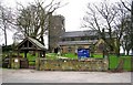
2
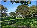
St Michael's East Ardsley: churchyard
The churchyard is still open for burials.
Image: © Stephen Craven
Taken: 15 Oct 2023
0.15 miles
3
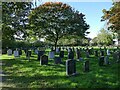
St Michael's East Ardsley: churchyard extension
The serried ranks of polished granite memorials make this look very much like a Council (secular) cemetery, but as far as I can tell it is an extension to the churchyard, just that a different style of memorial is permitted here.
Image: © Stephen Craven
Taken: 15 Oct 2023
0.16 miles
4
Orange Tree Grove - Forsythia Avenue
Image: © Betty Longbottom
Taken: 15 Feb 2013
0.17 miles
5
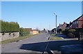
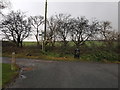
New Lane - looking towards Moor Knoll Lane
Image: © Betty Longbottom
Taken: 19 Feb 2013
0.18 miles
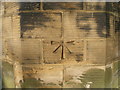
9

St Michael's East Ardsley: benchmark
Cut into the south-west corner of the tower, with a bolt, and still looking clean-cut. See Image for a closer view. None of the older maps avaialble online seem to show it, but bench-marks.org.uk gives a value of 141.01m.
Image: © Stephen Craven
Taken: 15 Oct 2023
0.20 miles
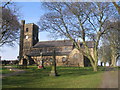
10
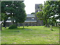
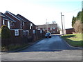
St Michaels Church
C of E church in East Ardsley.
Image: © James Allan
Taken: 25 Jun 2016
0.20 miles