IMAGES TAKEN NEAR TO
Highfield, WAKEFIELD, WF3 1LA
Introduction
This page details the photographs taken nearby to Highfield, WF3 1LA by members of the Geograph project.
The Geograph project started in 2005 with the aim of publishing, organising and preserving representative images for every square kilometre of Great Britain, Ireland and the Isle of Man.

There are currently over 7.5m images from over14,400 individuals and you can help contribute to the project by visiting https://www.geograph.org.uk
Image Map
Images are licensed for reuse under creativecommons.org/licenses/by-sa/2.0
Notes
- Clicking on the map will re-center to the selected point.
- The higher the marker number, the further away the image location is from the centre of the postcode.
Image Listing (44 Images Found)
Images are licensed for reuse under creativecommons.org/licenses/by-sa/2.0
Image
Details
Distance
1
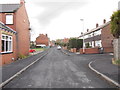
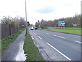
Highfield - looking towards Dewsbury Road
Image: © Betty Longbottom
Taken: 10 Apr 2012
0.02 miles
2
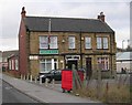
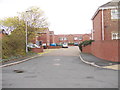
Tingley Working Men's Club - Highfield, Dewsbury Road
Image: © Betty Longbottom
Taken: 28 Jan 2008
0.03 miles
3
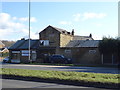
Upholstery business on Bradford Road (A653), Tingley
Image: © JThomas
Taken: 27 Feb 2020
0.04 miles
4
Tingley Common - viewed from near Highfield
Image: © Betty Longbottom
Taken: 10 Apr 2012
0.05 miles
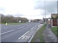
5
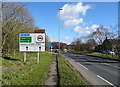
Bradford Road (A653)
Approaching Junction 28, M62 Motorway.
Image: © JThomas
Taken: 27 Feb 2020
0.06 miles
7
Tingley Common - viewed from near Highfield
Image: © Betty Longbottom
Taken: 10 Apr 2012
0.07 miles
9
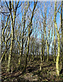
Woodland beside Bradford Road (A653), Tingley
Image: © JThomas
Taken: 27 Feb 2020
0.08 miles
10
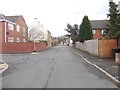
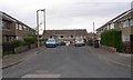
Kitson Street - looking towards Dewsbury Road
Image: © Betty Longbottom
Taken: 10 Apr 2012
0.09 miles