IMAGES TAKEN NEAR TO
Hesketh Lane, WAKEFIELD, WF3 1AU
Introduction
This page details the photographs taken nearby to Hesketh Lane, WF3 1AU by members of the Geograph project.
The Geograph project started in 2005 with the aim of publishing, organising and preserving representative images for every square kilometre of Great Britain, Ireland and the Isle of Man.

There are currently over 7.5m images from over14,400 individuals and you can help contribute to the project by visiting https://www.geograph.org.uk
Image Map
Images are licensed for reuse under creativecommons.org/licenses/by-sa/2.0
Notes
- Clicking on the map will re-center to the selected point.
- The higher the marker number, the further away the image location is from the centre of the postcode.
Image Listing (51 Images Found)
Images are licensed for reuse under creativecommons.org/licenses/by-sa/2.0
Image
Details
Distance
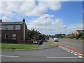
4
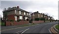
Lowry Road, West Ardsley
Approaching the junction with Dewsbury Road.
Image: © Mark Anderson
Taken: 15 Sep 2016
0.06 miles
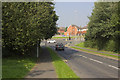
6
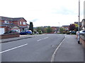
Dewsbury Road, Tingley
A dual-carriageway stretch of the A653 between Leeds and Dewsbury.
Image: © Stephen Craven
Taken: 17 Jun 2017
0.07 miles
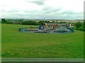
7
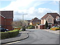
Turnberry Gardens - off Dewsbury Road
Image: © Betty Longbottom
Taken: 10 Apr 2012
0.09 miles
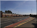
8
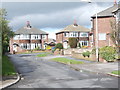
Thornfield Crescent - off Dewsbury Road
Image: © Betty Longbottom
Taken: 10 Apr 2012
0.09 miles