IMAGES TAKEN NEAR TO
Hollerton Lane, WAKEFIELD, WF3 1AB
Introduction
This page details the photographs taken nearby to Hollerton Lane, WF3 1AB by members of the Geograph project.
The Geograph project started in 2005 with the aim of publishing, organising and preserving representative images for every square kilometre of Great Britain, Ireland and the Isle of Man.

There are currently over 7.5m images from over14,400 individuals and you can help contribute to the project by visiting https://www.geograph.org.uk
Image Map
Images are licensed for reuse under creativecommons.org/licenses/by-sa/2.0
Notes
- Clicking on the map will re-center to the selected point.
- The higher the marker number, the further away the image location is from the centre of the postcode.
Image Listing (54 Images Found)
Images are licensed for reuse under creativecommons.org/licenses/by-sa/2.0
Image
Details
Distance
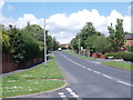
1
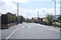
Hollerton Lane - looking towards Westerton Road
Image: © Betty Longbottom
Taken: 6 Jun 2012
0.02 miles
2

Old Hall Road - looking towards Smithy Lane
Image: © Betty Longbottom
Taken: 6 Jun 2012
0.05 miles
3
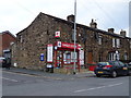
Tingley Store and Post Office
On Westerton Road.
Image: © JThomas
Taken: 6 Mar 2020
0.06 miles
4

Arriva bus on Haigh Moor Road, Tingley
On Route 117 to Wakefield.
Image: © JThomas
Taken: 6 Mar 2020
0.07 miles
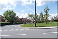
6
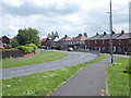
Westerton Road- viewed from Constable Road
Image: © Betty Longbottom
Taken: 6 Jun 2012
0.10 miles
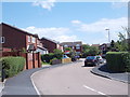
8
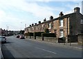
Houses on Westerton Road, West Ardsley
Image: © Humphrey Bolton
Taken: 16 Mar 2010
0.11 miles
10
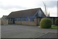
Our Lady of the Nativity Catholic Church - Westerton Road
Image: © Betty Longbottom
Taken: 28 Jan 2008
0.11 miles