IMAGES TAKEN NEAR TO
Padgett Way, WAKEFIELD, WF2 9UG
Introduction
This page details the photographs taken nearby to Padgett Way, WF2 9UG by members of the Geograph project.
The Geograph project started in 2005 with the aim of publishing, organising and preserving representative images for every square kilometre of Great Britain, Ireland and the Isle of Man.

There are currently over 7.5m images from over14,400 individuals and you can help contribute to the project by visiting https://www.geograph.org.uk
Image Map
Images are licensed for reuse under creativecommons.org/licenses/by-sa/2.0
Notes
- Clicking on the map will re-center to the selected point.
- The higher the marker number, the further away the image location is from the centre of the postcode.
Image Listing (117 Images Found)
Images are licensed for reuse under creativecommons.org/licenses/by-sa/2.0
Image
Details
Distance
2
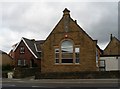
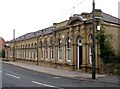
Offices on Flanshaw Lane
This building looks to have been a chapel, it is now offices.
Image: © SMJ
Taken: 15 Jul 2008
0.03 miles
3
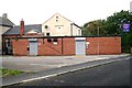
Alverthorpe Conservative Club - Green Lane
Image: © Betty Longbottom
Taken: 4 Oct 2008
0.03 miles