IMAGES TAKEN NEAR TO
Homestead Drive, WAKEFIELD, WF2 9PE
Introduction
This page details the photographs taken nearby to Homestead Drive, WF2 9PE by members of the Geograph project.
The Geograph project started in 2005 with the aim of publishing, organising and preserving representative images for every square kilometre of Great Britain, Ireland and the Isle of Man.

There are currently over 7.5m images from over14,400 individuals and you can help contribute to the project by visiting https://www.geograph.org.uk
Image Map
Images are licensed for reuse under creativecommons.org/licenses/by-sa/2.0
Notes
- Clicking on the map will re-center to the selected point.
- The higher the marker number, the further away the image location is from the centre of the postcode.
Image Listing (62 Images Found)
Images are licensed for reuse under creativecommons.org/licenses/by-sa/2.0
Image
Details
Distance
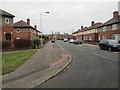
3
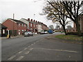
Alverthorpe Road - viewed from Moorhouse Avenue
Image: © Betty Longbottom
Taken: 2 Dec 2013
0.03 miles
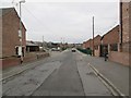
4
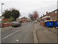
Moorhouse Avenue - Alverthorpe Road
Image: © Betty Longbottom
Taken: 2 Dec 2013
0.05 miles
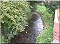
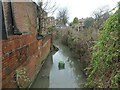
5
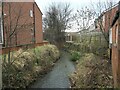
Alverthorpe Beck, downstream from Moorhouse Avenue
In the early 1800s, this beck powered textile mills in Wakefield, before water power was replaced by steam. Hebble Mill [wool] was upstream of here, Clarksons Mill [wool] and Marriots Mill [worsted] were downstream.
Image: © Christine Johnstone
Taken: 10 Jan 2021
0.05 miles
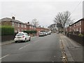
6
Alverthorpe Road - viewed from Moorhouse Avenue
Image: © Betty Longbottom
Taken: 2 Dec 2013
0.05 miles
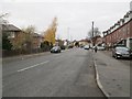
7
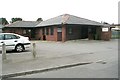
Homestead Clinic - off Alverthorpe Road
Image: © Betty Longbottom
Taken: 4 Oct 2008
0.06 miles
8
Alverthorpe Beck, upstream of Moorhouse Avenue
In the early 1800s, this beck powered textile mills in Wakefield, before water power was replaced by steam. Hebble Mill [wool] was upstream of here, Clarksons Mill [wool] and Marriots Mill [worsted] were downstream.
Image: © Christine Johnstone
Taken: 10 Jan 2021
0.06 miles