IMAGES TAKEN NEAR TO
Dewsbury Road, WAKEFIELD, WF2 9BS
Introduction
This page details the photographs taken nearby to Dewsbury Road, WF2 9BS by members of the Geograph project.
The Geograph project started in 2005 with the aim of publishing, organising and preserving representative images for every square kilometre of Great Britain, Ireland and the Isle of Man.

There are currently over 7.5m images from over14,400 individuals and you can help contribute to the project by visiting https://www.geograph.org.uk
Image Map
Images are licensed for reuse under creativecommons.org/licenses/by-sa/2.0
Notes
- Clicking on the map will re-center to the selected point.
- The higher the marker number, the further away the image location is from the centre of the postcode.
Image Listing (187 Images Found)
Images are licensed for reuse under creativecommons.org/licenses/by-sa/2.0
Image
Details
Distance
1
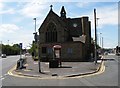
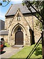
St Michael's Church
St Michael's Church is on a busy traffic island between Horbury Road, left, and Dewsbury Road, right. It looks as though it once had a tower or spire.
Image: © SMJ
Taken: 1 Jul 2008
0.01 miles
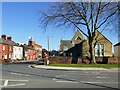
2
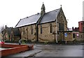
St Michael's Church - Westgate End
Image: © Betty Longbottom
Taken: 16 Jan 2008
0.02 miles
6
St Michael's, Westgate Common - church hall
The building nearest the camera is the former Sunday School, now the church hall.
Image: © Stephen Craven
Taken: 27 Feb 2022
0.03 miles
8
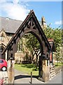
St Michael's Church gate
St Michael's church is on a busy traffic island between Horbury Road and Dewsbury Road. It has virtually no church yard.
Image: © SMJ
Taken: 1 Jul 2008
0.03 miles
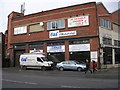
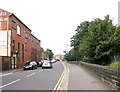
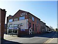
9

A to Z motorspares - Dewsbury Road
Image: © Betty Longbottom
Taken: 15 Feb 2010
0.03 miles
10
St Michael's Snooker Club, Alverthorpe Road, Wakefield
Named after (and maybe run by?) the Church of England parish.
Image: © Stephen Craven
Taken: 27 Feb 2022
0.03 miles