IMAGES TAKEN NEAR TO
Horbury Road, WAKEFIELD, WF2 8TR
Introduction
This page details the photographs taken nearby to Horbury Road, WF2 8TR by members of the Geograph project.
The Geograph project started in 2005 with the aim of publishing, organising and preserving representative images for every square kilometre of Great Britain, Ireland and the Isle of Man.

There are currently over 7.5m images from over14,400 individuals and you can help contribute to the project by visiting https://www.geograph.org.uk
Image Map
Images are licensed for reuse under creativecommons.org/licenses/by-sa/2.0
Notes
- Clicking on the map will re-center to the selected point.
- The higher the marker number, the further away the image location is from the centre of the postcode.
Image Listing (165 Images Found)
Images are licensed for reuse under creativecommons.org/licenses/by-sa/2.0
Image
Details
Distance
1
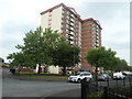
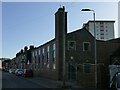
St Michael's House, Wakefield
One of three almost identical high-rise blocks of flats built in the city in the early 1960s. The others are Primrose House Image and Gill Sike House Image
Image: © Christine Johnstone
Taken: 9 Jun 2020
0.01 miles
2
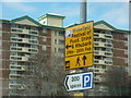
A Festival of rhubarb!
A notice on Horbury Road, Wakefield.
Image: © Ian S
Taken: 26 Feb 2011
0.02 miles
3
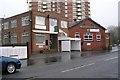
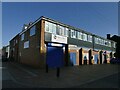
Westgate Common Working Men's Club - Park Grove Road
Image: © Betty Longbottom
Taken: 5 Feb 2008
0.04 miles
4
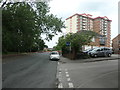
The route of Smithson's Tramroad, Wakefield
From 1798 to at least 1850, the tramroad ran along here, between gardens and private parkland. Now housing faces a public park.
Image: © Christine Johnstone
Taken: 9 Jun 2020
0.04 miles
5
Park Grove Road, Wakefield
From 1798 to at least 1850, this was the route of Smithson's tramroad - a horse-drawn railway that brought coal four miles from Low Laithes to Thornes Wharf.
Image: © Christine Johnstone
Taken: 9 Jun 2020
0.04 miles
8
Jamia Mosque, Grange Street, Wakefield (1)
A modern building in vernacular style, with only a small dome and crescent on top of a slender tower indicating its religious function.
Image: © Stephen Craven
Taken: 27 Feb 2022
0.05 miles
9
Grange House, Grange Street, Wakefield
A small business centre.
Image: © Stephen Craven
Taken: 27 Feb 2022
0.05 miles
10
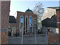
Jamia Mosque, Grange Street, Wakefield (2)
See also Image
Image: © Stephen Craven
Taken: 27 Feb 2022
0.05 miles