IMAGES TAKEN NEAR TO
Westfield Rise, WAKEFIELD, WF2 8FY
Introduction
This page details the photographs taken nearby to Westfield Rise, WF2 8FY by members of the Geograph project.
The Geograph project started in 2005 with the aim of publishing, organising and preserving representative images for every square kilometre of Great Britain, Ireland and the Isle of Man.

There are currently over 7.5m images from over14,400 individuals and you can help contribute to the project by visiting https://www.geograph.org.uk
Image Map
Images are licensed for reuse under creativecommons.org/licenses/by-sa/2.0
Notes
- Clicking on the map will re-center to the selected point.
- The higher the marker number, the further away the image location is from the centre of the postcode.
Image Listing (50 Images Found)
Images are licensed for reuse under creativecommons.org/licenses/by-sa/2.0
Image
Details
Distance
1
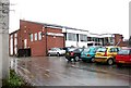
Lupset Working Men's Club - Horbury Road
Image: © Betty Longbottom
Taken: 5 Feb 2008
0.01 miles
3
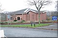
West Wakefield Methodist Church - Thornes Road
Image: © Betty Longbottom
Taken: 1 Dec 2014
0.06 miles
4
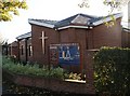
West Wakefield Methodist Church
West Wakefield Methodist Church is on the corner of Horbury Road and Thornes Road.
Image: © SMJ
Taken: 31 Oct 2008
0.06 miles
5
Lupset Crescent - Whinney Moor Avenue
Image: © Betty Longbottom
Taken: 13 Jul 2009
0.07 miles
6

Driveway to City of Wakefield Golf Club - Horbury Road
Image: © Betty Longbottom
Taken: 1 Dec 2014
0.07 miles
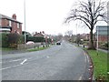
9
Manor Haigh Road - viewed from Lupset Crescent
Image: © Betty Longbottom
Taken: 1 Dec 2014
0.08 miles
10
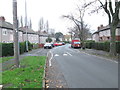
Manor Haigh Road - viewed from Lupset Crescent
Image: © Betty Longbottom
Taken: 1 Dec 2014
0.09 miles