IMAGES TAKEN NEAR TO
Milton Road, WAKEFIELD, WF2 8AB
Introduction
This page details the photographs taken nearby to Milton Road, WF2 8AB by members of the Geograph project.
The Geograph project started in 2005 with the aim of publishing, organising and preserving representative images for every square kilometre of Great Britain, Ireland and the Isle of Man.

There are currently over 7.5m images from over14,400 individuals and you can help contribute to the project by visiting https://www.geograph.org.uk
Image Map
Images are licensed for reuse under creativecommons.org/licenses/by-sa/2.0
Notes
- Clicking on the map will re-center to the selected point.
- The higher the marker number, the further away the image location is from the centre of the postcode.
Image Listing (58 Images Found)
Images are licensed for reuse under creativecommons.org/licenses/by-sa/2.0
Image
Details
Distance
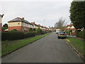
5
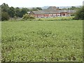
Bean field, rugby pitch
Beyond the farmer's fields are rugby pitches for a local amateur team.
Image: © SMJ
Taken: 30 Jun 2008
0.06 miles
6
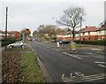
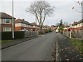
Broadway - viewed from Milton Road
Image: © Betty Longbottom
Taken: 24 Nov 2014
0.06 miles
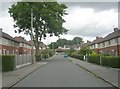
7
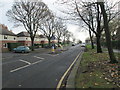
Broadway - viewed from Milton Road
Image: © Betty Longbottom
Taken: 24 Nov 2014
0.07 miles
9
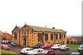
St George's Church
This Church is in a position just to the east of centre on the O/S grid it occupies
Image: © Bill Henderson
Taken: Unknown
0.10 miles
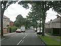
10
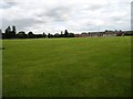
Sports pitches
These sports pitches are behind Snapethorpe Primary School
Image: © SMJ
Taken: 8 Jul 2008
0.10 miles