IMAGES TAKEN NEAR TO
Lake Court, WAKEFIELD, WF2 7SX
Introduction
This page details the photographs taken nearby to Lake Court, WF2 7SX by members of the Geograph project.
The Geograph project started in 2005 with the aim of publishing, organising and preserving representative images for every square kilometre of Great Britain, Ireland and the Isle of Man.

There are currently over 7.5m images from over14,400 individuals and you can help contribute to the project by visiting https://www.geograph.org.uk
Image Map
Images are licensed for reuse under creativecommons.org/licenses/by-sa/2.0
Notes
- Clicking on the map will re-center to the selected point.
- The higher the marker number, the further away the image location is from the centre of the postcode.
Image Listing (82 Images Found)
Images are licensed for reuse under creativecommons.org/licenses/by-sa/2.0
Image
Details
Distance
2
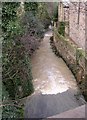
Stream downstream of Newmillerdam, off Barnsley Road, Crigglestone
The water is milky-brown due to the runoff from the woodland around the lake after prolonged rainfall.
Image: © Humphrey Bolton
Taken: 20 Jan 2007
0.01 miles
4
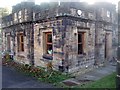
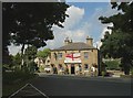
Newmillerdam Country Park - West Lodge
See Image
West Lodge, a former gamekeepers residence, is currently an Italian restaurant, La Fortezza.
Image: © Mike Kirby
Taken: 13 Nov 2010
0.03 miles
5
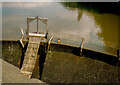
Sluice in the overflow weir, Newmillerdam
Image: © Humphrey Bolton
Taken: 6 Oct 1991
0.03 miles

7
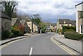
Cars travelling across the dam towards Barnsley
The A61 travels through Newmillerdam.
Image: © Pauline E
Taken: 24 Mar 2010
0.04 miles
8
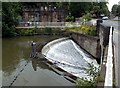
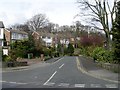
Newmillerdam outlet weir
On the right hand edge of the photo can be seen the A61 Barnsley Road.
Image: © John Fielding
Taken: 2 Jul 2007
0.04 miles
9
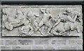
Bas relief on a little building, Newmillerdam
A rather chaotic scene that looks to be from Greek mythology. The building must have been built recently, as it is not on the large-scale map on the Historic England site, although it is on the Geograph submission map. It is behind the Fortezza restaurant, which is still captioned West Lodge on maps, next to the car park. It appears to be a toilet, but there is no sign to say so and it is not shown on the Council's map of the country park: https://www.wakefield.gov.uk/Documents/sports-leisure/parks-countryside/newmillerdam-country-park.pdf.
Image: © Humphrey Bolton
Taken: 21 Feb 2023
0.04 miles