IMAGES TAKEN NEAR TO
Secker Street, WAKEFIELD, WF2 7SA
Introduction
This page details the photographs taken nearby to Secker Street, WF2 7SA by members of the Geograph project.
The Geograph project started in 2005 with the aim of publishing, organising and preserving representative images for every square kilometre of Great Britain, Ireland and the Isle of Man.

There are currently over 7.5m images from over14,400 individuals and you can help contribute to the project by visiting https://www.geograph.org.uk
Image Map
Images are licensed for reuse under creativecommons.org/licenses/by-sa/2.0
Notes
- Clicking on the map will re-center to the selected point.
- The higher the marker number, the further away the image location is from the centre of the postcode.
Image Listing (128 Images Found)
Images are licensed for reuse under creativecommons.org/licenses/by-sa/2.0
Image
Details
Distance
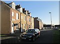
3
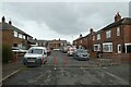
Traffic calming on Major Street
The road is divided by these barriers preventing through traffic.
Image: © DS Pugh
Taken: 25 Feb 2023
0.04 miles
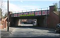
8
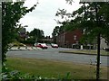
Denby Dale Road / Thornes Lane roundabout
Looking across Denby Dale Road and along Thornes Lane
Image: © Rich Tea
Taken: 23 Jun 2006
0.06 miles