IMAGES TAKEN NEAR TO
Penrose Place, WAKEFIELD, WF2 7QG
Introduction
This page details the photographs taken nearby to Penrose Place, WF2 7QG by members of the Geograph project.
The Geograph project started in 2005 with the aim of publishing, organising and preserving representative images for every square kilometre of Great Britain, Ireland and the Isle of Man.

There are currently over 7.5m images from over14,400 individuals and you can help contribute to the project by visiting https://www.geograph.org.uk
Image Map
Images are licensed for reuse under creativecommons.org/licenses/by-sa/2.0
Notes
- Clicking on the map will re-center to the selected point.
- The higher the marker number, the further away the image location is from the centre of the postcode.
Image Listing (50 Images Found)
Images are licensed for reuse under creativecommons.org/licenses/by-sa/2.0
Image
Details
Distance
1
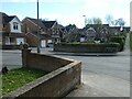
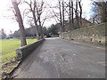
Penrose Place, off Fishpond Lane
Built partly on the site of the former fishpond on the north side of the lane.
Image: © Christine Johnstone
Taken: 8 Apr 2022
0.01 miles
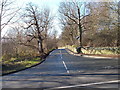
2
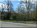
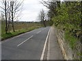
Open access woodland, Crigglestone
Between Fishponds Lane and Haveroid Lane. The large-scale OS map surveyed in 1850 shows this area as fields called West Croft.
Image: © Christine Johnstone
Taken: 8 Apr 2022
0.06 miles
4
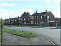
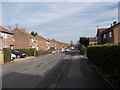
South side of Hendal Lane, Chapelthorpe
Wakefield Council built this estate in the 1950s.
Image: © Christine Johnstone
Taken: 8 Apr 2022
0.08 miles
8
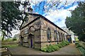
St James' church, Chapelthorpe
West and south sides, for full description see: https://www.geograph.org.uk/photo/7763350
Image: © Chris Morgan
Taken: 26 Apr 2024
0.12 miles
9
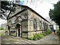
Church of St James
A grade II listed church dating from 1771, destroyed by fire in 1951 and rebuilt in facsimile.
Image: © Graham Hogg
Taken: 26 Apr 2024
0.12 miles
10
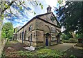
St James' church, Chapelthorpe
North and west end of a small hidden chapel with an interesting history copied below from the C of E website; https://facultyonline.churchofengland.org/church-heritage-record-chapelthorpe-st-james-646139#Building
Description of Archaeology and History
The foundation of the Ecclesiastical Parish of St James' dates from 1843 when it became a Parish in its own right, a factor necessitated by the growth of the coal and fireclay industries in the district.
The first building to occupy the site was that of the Chapel of St James' erected in c1285. The Chapel formed an outlying Chapelry to the adjoining Parish of St Helen, Sandal Magna.
In 1545, during the period of the Dissolution, the Chapel was closed as a place of worship and used as a cottage, being re-opened as a place of worship by local demand in 1576, when several alterations were made to the structure.
In 1771 the Chapel had fallen into a state of ruinous decay and the whole of the structure was demolished. A new Chapel was erected on the site in 1773, the western end of the present Church dating from this period. In 1843, the Chapelry of St James' became an Ecclesiastical Parish in its own right, its first Incumbent being instituted in June 1844.In 1882 the east end of the Church was taken down and the Transepts added, forming the structure as evidenced today.
In June 1951, the interior of the Church was totally gutted by fire. Within 13 months of the fire however, the building had been re-furbished and re-Consecrated in its present form.
Exterior Description
After the fire of 1951, the church was rebuilt in facsimile reusing original C18 walls and openings. The roof is Ashlar stone slate and in Classical style. Interior nave is rectangular with plinth, sill band and impost band. 3-bay symmetrical pedimented gabled end has 2 original doorways with architraves, pulvinated friezes, consoles and triangular pediments set within semi-circular-arched recesses, the voussoirs aligned to the courses. Centre bay has 3-light wooden framed window with same above. Quatrefoil set in apex. Coped gable surmounted by open drum with ogee cap supported by Tuscan columns. Ritual East end has large Venetian window – the imposts supported by paired engaged Tuscan brick columns overlaid with damp-proofed plaster. This work was carried out by Peter Cox Preservation in June 1987 and remain in sound condition. Open pedimented gable. Left and right returns of 7 bays: 6 bays of semi-circular arched windows with architraves. 7th bay breaking forward with pedimented gables. Doorway set in side wall on South side. Interior: circa 1951. East window has stained glass of that date.
Image: © Chris Morgan
Taken: 26 Apr 2024
0.12 miles