IMAGES TAKEN NEAR TO
Shaw Fold, WAKEFIELD, WF2 7LT
Introduction
This page details the photographs taken nearby to Shaw Fold, WF2 7LT by members of the Geograph project.
The Geograph project started in 2005 with the aim of publishing, organising and preserving representative images for every square kilometre of Great Britain, Ireland and the Isle of Man.

There are currently over 7.5m images from over14,400 individuals and you can help contribute to the project by visiting https://www.geograph.org.uk
Image Map
Images are licensed for reuse under creativecommons.org/licenses/by-sa/2.0
Notes
- Clicking on the map will re-center to the selected point.
- The higher the marker number, the further away the image location is from the centre of the postcode.
Image Listing (103 Images Found)
Images are licensed for reuse under creativecommons.org/licenses/by-sa/2.0
Image
Details
Distance
1
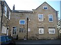
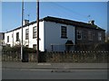
Nos 3 and 5, Shaw Fold, Sandal
A grade II listed house of 2 builds. No.3 is dated C17, perhaps once integral with No 1, far left of picture. No.5, gable end view, right of picture, is dated late C18. Both houses are built in coursed squared stone with flagged roofs.
LBS Number: 445071
Image: © Mike Kirby
Taken: 1 Mar 2011
0.01 miles
2
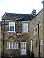
No1. Shaw Fold, Sandal
A small grade II listed cottage built in coursed squared stone with stone flagged roof, dating back to the C17th century.
LBS Number: 445070
Image: © Mike Kirby
Taken: 1 Mar 2011
0.01 miles
5
Sandal House, Barnsley Road
A grade II listed building, part pebble-dashed and painted, with a low pitched stone flagged hipped roof, dated early C19. This may be a re-fronting of an C18 building, as the rear part is of that date.
LBS Number: 441440
Image: © Mike Kirby
Taken: 1 Mar 2011
0.04 miles
6
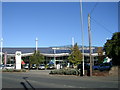
Guy Salmon - Land Rover dealership - Barnsley Road
Image: © Betty Longbottom
Taken: 25 Oct 2010
0.05 miles
8
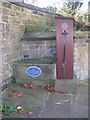
Sandal Village Pump - Barnsley Road
Image: © Betty Longbottom
Taken: 25 Oct 2010
0.06 miles
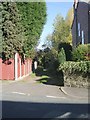
9
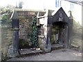
Alcove, Barnsley Road, Sandal (1)
This alcove, just south of Barleywood House, is a grade II listed, small square gabled stone building possibly built to home a pump or public seat, with a date of 1845 in the gable peak. See Image for the alcoves location.
LBS Number: 441439
Image: © Mike Kirby
Taken: 1 Mar 2011
0.06 miles
10
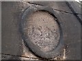
Alcove, Barnsley Road, Sandal (2)
Although weathered, the date of 1845 can still be made out on the gable peak of the alcove. See Image
Image: © Mike Kirby
Taken: 1 Mar 2011
0.06 miles