IMAGES TAKEN NEAR TO
Cotham Drive, WAKEFIELD, WF2 7FA
Introduction
This page details the photographs taken nearby to Cotham Drive, WF2 7FA by members of the Geograph project.
The Geograph project started in 2005 with the aim of publishing, organising and preserving representative images for every square kilometre of Great Britain, Ireland and the Isle of Man.

There are currently over 7.5m images from over14,400 individuals and you can help contribute to the project by visiting https://www.geograph.org.uk
Image Map
Images are licensed for reuse under creativecommons.org/licenses/by-sa/2.0
Notes
- Clicking on the map will re-center to the selected point.
- The higher the marker number, the further away the image location is from the centre of the postcode.
Image Listing (39 Images Found)
Images are licensed for reuse under creativecommons.org/licenses/by-sa/2.0
Image
Details
Distance
1
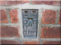
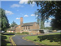
Ordnance Survey Flush Bracket S9043
This bracket can be found on the wall of Crigglestone Cemetery.
For more detail see : http://www.bench-marks.org.uk/bm21350
Image: © Peter Wood
Taken: 17 Feb 2012
0.06 miles
2

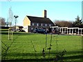
Crigglestone Cemetery Lodge - Standbridge Lane
Image: © Betty Longbottom
Taken: 15 Apr 2008
0.08 miles
3
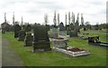
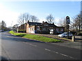
Crigglestone Cemetery - Standbridge Lane
Image: © Betty Longbottom
Taken: 15 Apr 2008
0.08 miles
4
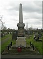
Crigglestone Cemetery War Memorial - Standbridge Lane
Image: © Betty Longbottom
Taken: 15 Apr 2008
0.09 miles
5
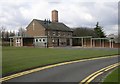
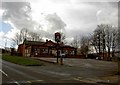
Wakefield Crematorium - Standbridge Lane
Image: © Betty Longbottom
Taken: 15 Apr 2008
0.10 miles