IMAGES TAKEN NEAR TO
Duke Of York Avenue, WAKEFIELD, WF2 7DT
Introduction
This page details the photographs taken nearby to Duke Of York Avenue, WF2 7DT by members of the Geograph project.
The Geograph project started in 2005 with the aim of publishing, organising and preserving representative images for every square kilometre of Great Britain, Ireland and the Isle of Man.

There are currently over 7.5m images from over14,400 individuals and you can help contribute to the project by visiting https://www.geograph.org.uk
Image Map
Images are licensed for reuse under creativecommons.org/licenses/by-sa/2.0
Notes
- Clicking on the map will re-center to the selected point.
- The higher the marker number, the further away the image location is from the centre of the postcode.
Image Listing (50 Images Found)
Images are licensed for reuse under creativecommons.org/licenses/by-sa/2.0
Image
Details
Distance
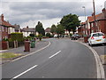
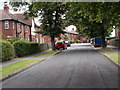
3
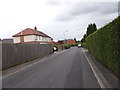
Duke of York Avenue - viewed from Castle Avenue
Image: © Betty Longbottom
Taken: 7 Jul 2015
0.09 miles
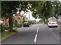
4
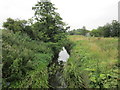
Rutland Avenue - Duke of York Avenue
Image: © Betty Longbottom
Taken: 7 Jul 2015
0.09 miles
5
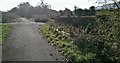
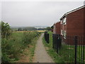
Track and Bridge near Pugney's Country Park
Image: © Darren Haddock
Taken: 25 Oct 2018
0.10 miles
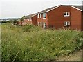
6
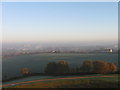
Misty view from Sandal Castle, Wakefield
Image: © Alex McGregor
Taken: 16 Nov 2010
0.10 miles
10

View to the city of Wakefield
View to the city of Wakefield from Sandal Castle. The spire of the cathedral can be seen on the skyline to the right of centre.
Image: © Philip Halling
Taken: 29 Jun 2018
0.12 miles