IMAGES TAKEN NEAR TO
Marriott Grove, WAKEFIELD, WF2 6RP
Introduction
This page details the photographs taken nearby to Marriott Grove, WF2 6RP by members of the Geograph project.
The Geograph project started in 2005 with the aim of publishing, organising and preserving representative images for every square kilometre of Great Britain, Ireland and the Isle of Man.

There are currently over 7.5m images from over14,400 individuals and you can help contribute to the project by visiting https://www.geograph.org.uk
Image Map
Images are licensed for reuse under creativecommons.org/licenses/by-sa/2.0
Notes
- Clicking on the map will re-center to the selected point.
- The higher the marker number, the further away the image location is from the centre of the postcode.
Image Listing (29 Images Found)
Images are licensed for reuse under creativecommons.org/licenses/by-sa/2.0
Image
Details
Distance
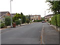
1
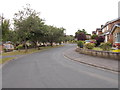
Marriott Grove - looking towards Walton Lane
Image: © Betty Longbottom
Taken: 24 Jul 2015
0.03 miles
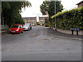
3
St Helen's Grove - looking towards Walton Lane
Image: © Betty Longbottom
Taken: 24 Jul 2015
0.07 miles

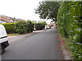
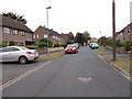
7
Walton Lane - viewed from Marriott Grove
Image: © Betty Longbottom
Taken: 24 Jul 2015
0.08 miles
8
Walton Lane - viewed from Marriott Grove
Image: © Betty Longbottom
Taken: 24 Jul 2015
0.09 miles
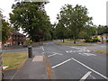
9
Sandal Hall Close - looking towards Walton Lane
Image: © Betty Longbottom
Taken: 24 Jul 2015
0.10 miles
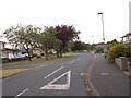
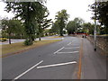
10
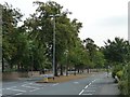
Central reservation, Walton Lane, Sandal
Often found on a 'main' suburban road developed in the 1930s or 1950s.
Image: © Christine Johnstone
Taken: 3 Aug 2011
0.10 miles