IMAGES TAKEN NEAR TO
Barnsley Road, WAKEFIELD, WF2 6QE
Introduction
This page details the photographs taken nearby to Barnsley Road, WF2 6QE by members of the Geograph project.
The Geograph project started in 2005 with the aim of publishing, organising and preserving representative images for every square kilometre of Great Britain, Ireland and the Isle of Man.

There are currently over 7.5m images from over14,400 individuals and you can help contribute to the project by visiting https://www.geograph.org.uk
Image Map
Images are licensed for reuse under creativecommons.org/licenses/by-sa/2.0
Notes
- Clicking on the map will re-center to the selected point.
- The higher the marker number, the further away the image location is from the centre of the postcode.
Image Listing (53 Images Found)
Images are licensed for reuse under creativecommons.org/licenses/by-sa/2.0
Image
Details
Distance
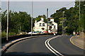
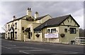
5
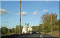
Yet another picture of The Pledwick Well Arms
From the A61 heading towards Wakefield from Barnsley.
Image: © Steve Fareham
Taken: 22 Oct 2008
0.03 miles
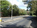
6
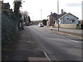
Barnsley Road - viewed from Pledwick Lane
Image: © Betty Longbottom
Taken: 9 Feb 2016
0.03 miles
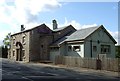
7
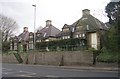
Harrison's Home for the Aged Poor - Barnsley Road
Endowed by Samuel F Harrison in the 1880s.
Image: © Betty Longbottom
Taken: 15 Apr 2008
0.03 miles
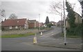
10
Barnsley Road - viewed from Pledwick Lane
Image: © Betty Longbottom
Taken: 9 Feb 2016
0.05 miles