IMAGES TAKEN NEAR TO
Common Lane, WAKEFIELD, WF2 6PS
Introduction
This page details the photographs taken nearby to Common Lane, WF2 6PS by members of the Geograph project.
The Geograph project started in 2005 with the aim of publishing, organising and preserving representative images for every square kilometre of Great Britain, Ireland and the Isle of Man.

There are currently over 7.5m images from over14,400 individuals and you can help contribute to the project by visiting https://www.geograph.org.uk
Image Map
Images are licensed for reuse under creativecommons.org/licenses/by-sa/2.0
Notes
- Clicking on the map will re-center to the selected point.
- The higher the marker number, the further away the image location is from the centre of the postcode.
Image Listing (13 Images Found)
Images are licensed for reuse under creativecommons.org/licenses/by-sa/2.0
Image
Details
Distance
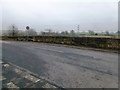
1
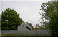
Steel footbridge over railway line at Walton.
Image: © Steve Fareham
Taken: 19 Sep 2007
0.08 miles

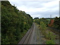
3
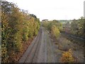
Railway line south towards Barnsley
The railway looks as if it was once much wider. The bridge in the distance is a footbridge.
Image: © Pauline E
Taken: 4 Nov 2011
0.14 miles
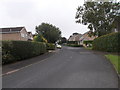
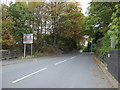
9
Copper Beech Court - Chestnut Avenue
Image: © Betty Longbottom
Taken: 8 Sep 2015
0.22 miles
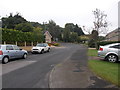
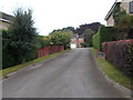
10
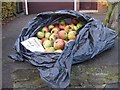
Eaters, help yourself
So says the sign and it looks as if the birds have been doing just that. It's been a good crop of apples this year.
Image: © Pauline E
Taken: 4 Nov 2011
0.23 miles