IMAGES TAKEN NEAR TO
Pledwick Rise, WAKEFIELD, WF2 6DH
Introduction
This page details the photographs taken nearby to Pledwick Rise, WF2 6DH by members of the Geograph project.
The Geograph project started in 2005 with the aim of publishing, organising and preserving representative images for every square kilometre of Great Britain, Ireland and the Isle of Man.

There are currently over 7.5m images from over14,400 individuals and you can help contribute to the project by visiting https://www.geograph.org.uk
Image Map
Images are licensed for reuse under creativecommons.org/licenses/by-sa/2.0
Notes
- Clicking on the map will re-center to the selected point.
- The higher the marker number, the further away the image location is from the centre of the postcode.
Image Listing (51 Images Found)
Images are licensed for reuse under creativecommons.org/licenses/by-sa/2.0
Image
Details
Distance
3
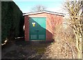
Electricity Substation No 5891 - Pledwick Crescent
Image: © Betty Longbottom
Taken: 9 Feb 2016
0.04 miles
6
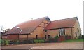
Sandal, St Peter & Paul R.C. Church
This Church stands at the junction of Standbridge Lane and the A6186, Dale Road.
Image: © Bill Henderson
Taken: Unknown
0.05 miles
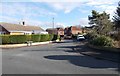
8
Pledwick Lane - viewed from Kestrel Drive
Image: © Betty Longbottom
Taken: 9 Feb 2016
0.07 miles