IMAGES TAKEN NEAR TO
Kenmore Road, WAKEFIELD, WF2 0XE
Introduction
This page details the photographs taken nearby to Kenmore Road, WF2 0XE by members of the Geograph project.
The Geograph project started in 2005 with the aim of publishing, organising and preserving representative images for every square kilometre of Great Britain, Ireland and the Isle of Man.

There are currently over 7.5m images from over14,400 individuals and you can help contribute to the project by visiting https://www.geograph.org.uk
Image Map
Images are licensed for reuse under creativecommons.org/licenses/by-sa/2.0
Notes
- Clicking on the map will re-center to the selected point.
- The higher the marker number, the further away the image location is from the centre of the postcode.
Image Listing (8 Images Found)
Images are licensed for reuse under creativecommons.org/licenses/by-sa/2.0
Image
Details
Distance
1

Gate 1 entrance to Morrisons supermarkets warehouse Wakefield 41
Image: © Steve Fareham
Taken: 3 Dec 2007
0.09 miles
2
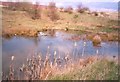
Temporary pond, Wakefield 41 Business Park, Wrenthorpe
This site is now built up, but back in 2000 it contained this pond, a little hidden wildlife sanctuary.
Image: © Humphrey Bolton
Taken: 16 Apr 2000
0.10 miles
3

Grandstand Road, newly tarmacked
A byway in Wakefield 41 industrial park. Between 1745 and 1794, there was a racecourse here in Wakefield's Outwood. John Carr designed a 'Grand Stand' for the course, and this was the road that led to it. The byway was officially named 'Grandstand Road' in 1890 and Carr's derelict Grand Stand was blown up in 1924.
Image: © Christine Johnstone
Taken: 2 Apr 2025
0.18 miles
4
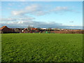
Wakefield hilltop
This point on the Outwood edge of Wakefield is one of the highest points in the city, but the view has been limited in recent times by the building of a big new housing estate. This is the view north west, over East Street, and on to the white rooftops of the Wakefield 41 industrial area, named after its nearby M1 junction.
Image: © John Goldsmith
Taken: 26 Dec 2011
0.19 miles
5

Electricity substation, Wakefield 41 industrial park
On Grandstand Road, but identified as Telford Way 7319. The building behind is on Telford Way.
Image: © Christine Johnstone
Taken: 2 Apr 2025
0.21 miles
6
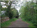
Grandstand Road
A very welcome oddity through a very busy trading estate
Image: © John Slater
Taken: 12 May 2013
0.23 miles
7

Lawns Lane
A byway linking Lingwell Gate and Carr Gate, along what was the western boundary of Wakefield's Outwood.
Image: © Christine Johnstone
Taken: 2 Apr 2025
0.23 miles