IMAGES TAKEN NEAR TO
Allison Terrace, WAKEFIELD, WF2 0SL
Introduction
This page details the photographs taken nearby to Allison Terrace, WF2 0SL by members of the Geograph project.
The Geograph project started in 2005 with the aim of publishing, organising and preserving representative images for every square kilometre of Great Britain, Ireland and the Isle of Man.

There are currently over 7.5m images from over14,400 individuals and you can help contribute to the project by visiting https://www.geograph.org.uk
Image Map
Images are licensed for reuse under creativecommons.org/licenses/by-sa/2.0
Notes
- Clicking on the map will re-center to the selected point.
- The higher the marker number, the further away the image location is from the centre of the postcode.
Image Listing (58 Images Found)
Images are licensed for reuse under creativecommons.org/licenses/by-sa/2.0
Image
Details
Distance
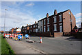
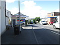
2
Greenlay Drive - looking towards Batley Road
Image: © Betty Longbottom
Taken: 3 Sep 2013
0.02 miles
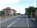
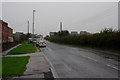
6
New Row - looking towards Batley Road
Image: © Betty Longbottom
Taken: 3 Sep 2013
0.09 miles
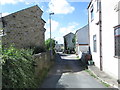
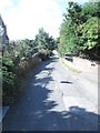
8
Gawthorpe Lanetowards Batley Road, Kirkhamgate
Image: © Ian S
Taken: 18 Apr 2018
0.11 miles