IMAGES TAKEN NEAR TO
Westfield Place, WAKEFIELD, WF2 0SF
Introduction
This page details the photographs taken nearby to Westfield Place, WF2 0SF by members of the Geograph project.
The Geograph project started in 2005 with the aim of publishing, organising and preserving representative images for every square kilometre of Great Britain, Ireland and the Isle of Man.

There are currently over 7.5m images from over14,400 individuals and you can help contribute to the project by visiting https://www.geograph.org.uk
Image Map
Images are licensed for reuse under creativecommons.org/licenses/by-sa/2.0
Notes
- Clicking on the map will re-center to the selected point.
- The higher the marker number, the further away the image location is from the centre of the postcode.
Image Listing (71 Images Found)
Images are licensed for reuse under creativecommons.org/licenses/by-sa/2.0
Image
Details
Distance
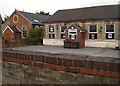
1
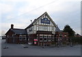
The Star Inn, Kirkhamgate
Currently being refurbished.
On Batley Road.
Image: © JThomas
Taken: 6 Mar 2020
0.04 miles

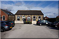
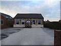
6

Lindale Methodist Church, Kirkhamgate
The foundation stone indicates that this was originally a Primitive Methodist Chapel.
Image: © Christine Johnstone
Taken: 17 Mar 2010
0.06 miles
7
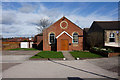
Lindale Methodist Church
On Brandy Carr Road, Kirkhamgate.
Image: © Ian S
Taken: 18 Apr 2018
0.06 miles