IMAGES TAKEN NEAR TO
Keren Grove, WAKEFIELD, WF2 0NR
Introduction
This page details the photographs taken nearby to Keren Grove, WF2 0NR by members of the Geograph project.
The Geograph project started in 2005 with the aim of publishing, organising and preserving representative images for every square kilometre of Great Britain, Ireland and the Isle of Man.

There are currently over 7.5m images from over14,400 individuals and you can help contribute to the project by visiting https://www.geograph.org.uk
Image Map
Images are licensed for reuse under creativecommons.org/licenses/by-sa/2.0
Notes
- Clicking on the map will re-center to the selected point.
- The higher the marker number, the further away the image location is from the centre of the postcode.
Image Listing (76 Images Found)
Images are licensed for reuse under creativecommons.org/licenses/by-sa/2.0
Image
Details
Distance
2
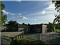
Jerry Clay Academy, Wrenthorpe
A primary school on the edge of the town.
Image: © Stephen Craven
Taken: 15 Oct 2023
0.03 miles
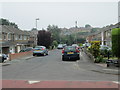
3
Jerry Clay Lane, Wrenthorpe.
Looking NW.
Image: © Steve Partridge
Taken: 8 Feb 2006
0.04 miles

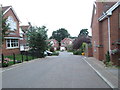
5
Jerry Clay Drive - Jerry Clay Lane
Image: © Betty Longbottom
Taken: 22 Jul 2013
0.06 miles
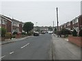
6
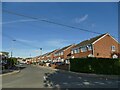
Jerry Clay Drive, Wrenthorpe
Opposite the school of the same name. The road is built on the site of a former rope works.
Image: © Stephen Craven
Taken: 15 Oct 2023
0.07 miles
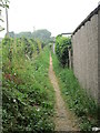
7

Track and footpath off Jerry Clay Lane
To the left is a private track to No. 50 Jerry Clay Lane, and to the right of the hedge is a public footpath to Trough Well Lane.
Image: © Stephen Craven
Taken: 15 Oct 2023
0.07 miles
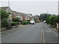
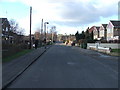
10
Sunny Hill Close - Wrenthorpe Lane
Image: © Betty Longbottom
Taken: 10 Sep 2013
0.09 miles