IMAGES TAKEN NEAR TO
Lincoln Street, WAKEFIELD, WF2 0ED
Introduction
This page details the photographs taken nearby to Lincoln Street, WF2 0ED by members of the Geograph project.
The Geograph project started in 2005 with the aim of publishing, organising and preserving representative images for every square kilometre of Great Britain, Ireland and the Isle of Man.

There are currently over 7.5m images from over14,400 individuals and you can help contribute to the project by visiting https://www.geograph.org.uk
Image Map
Images are licensed for reuse under creativecommons.org/licenses/by-sa/2.0
Notes
- Clicking on the map will re-center to the selected point.
- The higher the marker number, the further away the image location is from the centre of the postcode.
Image Listing (60 Images Found)
Images are licensed for reuse under creativecommons.org/licenses/by-sa/2.0
Image
Details
Distance
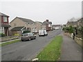
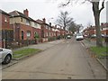
1
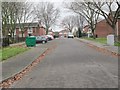
Gibson Avenue - looking towards Peacock Avenue
Image: © Betty Longbottom
Taken: 2 Dec 2013
0.04 miles
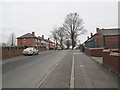
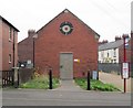
3

A pair of large houses, Balne Lane, Alverthorpe, Wakefield
A well-preserved pair of large semi-detached houses from, I think, the turn of the 19th and 20th centuries.
Image: © Humphrey Bolton
Taken: 11 Sep 2008
0.07 miles
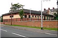
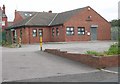
4
Electricity Substation No 5158 - Peacock Avenue
Image: © Betty Longbottom
Taken: 2 Dec 2013
0.08 miles
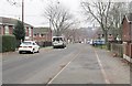
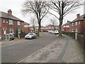
6
Walnut Avenue - looking towards Peacock Avenue
Image: © Betty Longbottom
Taken: 2 Dec 2013
0.08 miles